|
|
|
|
| Topo Trail Map | Map Legend | Bikerag Pictures |


|
WV - Gauley Mountain Trail - Red Run - Right Fork - Tea Creek Mountain Trail - Mountain Bike Trail Review with Map and Pictures |
|||||||||||||||||||||||||||||||||||||||||||||||||||||||||||||||||||||||||||||
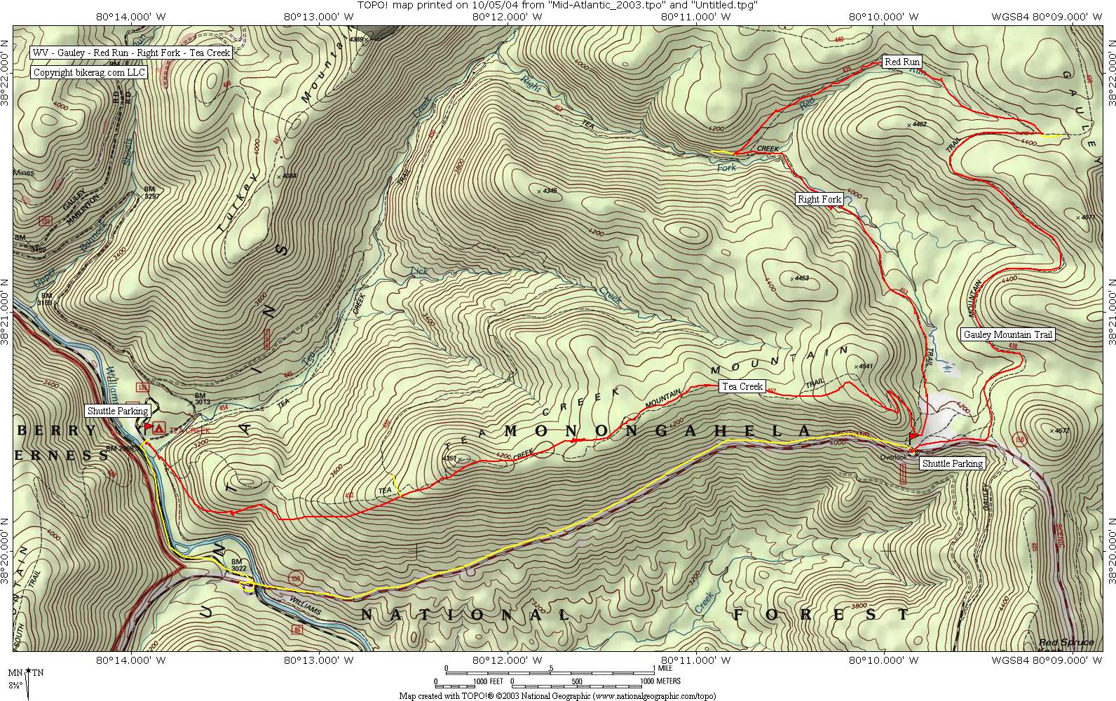
Directions - Best to do this ride as a
shuttle...From Snowshoe take 219 south towards Slatyfork/Marlinton. Take a
right on WV 150, Highland Scenic Highway. After 4 miles you will see
the Little Laurel Scenic Overlook on the left hand side. Directly
across from this on the right is a small gravel parking lot that you will
come back to after dropping off your shuttle car at the Tea Creek Campground
further down 150. Also here is the trailhead for the Tea Creek
Mountain Trail if you wanted to just ride this trail instead of the entire
ride loop described (don't confuse this with the Tea Creek Trail which is an
entirely different). So back to the shuttle...descend down 150
and immediately after crossing the Williams River take a left for the Tea
Creek Campground and follow signs to the campground leaving a car at the
picnic area. Drive back up 150 to the Little Laurel Overlook parking
in the small gravel lot on the left hand side. |
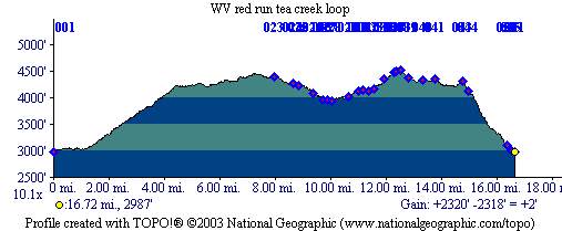
Description - The full loop is like this...from the gravel parking area across from little laurel overlook, take a left on 150 and pedal up pavement .56 miles, take left onto Gauley Mountain Trail for 2.67, Gauley is decent 1.5 track with some roots and a tinge of mud here and there (if it recently rained it would be alot muddier), goes through and open meadow and then one log dismount, go up alittle bit further and look for the left on Red Run trail, travel on Red Run for 2.01 miles of awesome, super mossy, rooty and rocky singletrack that makes me feel wet in the pants, lots of holes to get stuck in (hot lips holes), but you can clean the whole thing if your a competent technical rider. At a downed tree with debris take a sharp left, like switchback down to go a bit further to the intersection with the Right Fork trail (not clearly signed). Bear left onto Right Fork...you will cross a couple streams and hike up a rock staircase pretty quickly...travel on Right fork for 1.84 miles, some parts are cool, some are wet mushy suck the life out of you, up a 1% grade...you'll be in granny two if it's wet. Look for a sign that points to the right for Tea Creek Mountain Trail, follow up steep hill with a couple logs across it to clearing where you will be directed back to the overlook where you parked or shuttled. Don't dare go back to your car, go up to the kiosk that's most likely empty and take the trail behind it up the hill to the right - that's Tea Creek Mtn. Trail. A sweet singletrack climb with switchbacks gains vertical easily. Once your up, the rocks will start to appear...more and more rocks, to the point where it truly is like riding on bowling balls at the top.. The good thing is its all rideable, but most people who have good technical skills may dab and possibly crash at some point.. At the top, the trail goes up and down a bit before finally descending back to tea creek campground. Total trip on tea creek mtn. trail is about 5 miles, the final descent is one of the best! it's awesome, off camber single with some fun mini jumps and some techs, bottom has some sleezy switchbacks.. At bottom, take right along the Williams River for very short distance and get in your car and get the shuttle or start pedaling up 150 if you didn't shuttle. This ride is awesome, best thing was variety, a real adventure without being in the middle of no-where.. Would I go back? Im probably there right now, cant wait to find more goodies in the area. Loops - you can do just Gauley Mtn. Trail-red run-right fork or just tea creek mountain trail or both combined as described. Pre-ride Music: |
Total Miles: 12 miles of dirt, 5 miles of
pavement |
Elevation Change Feet - 2400 (1200 of the 2400 can be done with shuttle) |
|
Disclaimer: Caution - Use this map at your
own risk. Bikerag.com and affiliates will not accept
responsibility for an personal injury, property damage or trespassing while
using this map. Trail users shall obey all signs, and always obtain
permission from the land owner to use trails for any sporting activity.
Permission to use trails should not be assumed. This map simply
contains topographical information and trails that existed at one time.
Trails shown maybe be missing, not accurate, closed, overgrown etc.... |
To
view larger version of map, right click on map and select View Image. |
| ||||||||||||||||||||||||||||||||||||||||||||||||||||||||||||||||||||||