|
|
|
|
| Topo Trail Map FOTW map - good!! |
Map Legend | Bikerag Pictures |


|
|
|
|
| Topo Trail Map FOTW map - good!! |
Map Legend | Bikerag Pictures |
|
VT - Mobbs Hill, Mobb's Valley, Arcana, Americana - Mountain Bike Trail Review with Map and Pictures |
|||||||||||||||||||||||||||||||||||||||||||||||||||||||||||||||||||||||||||||
DO NOT RIDE HERE IF ITS
WET!! This area gets lots of traffic and is very sensitive.
|
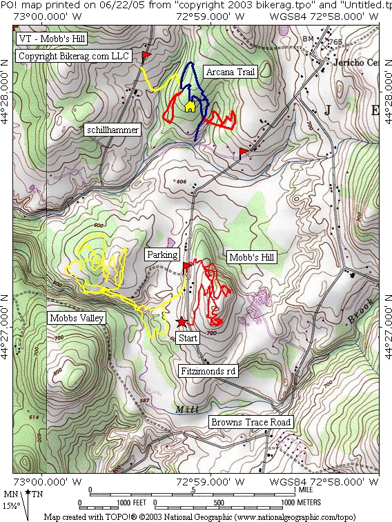
Directions - From 89 south, exit 11, left at off ramp, drive .2 miles take right on 117 West then IMMEDIATE right on Governor peck road - travel 2.3 miles and take left at stop sign on to brown trace road, .1 miles take left on Fitzimonds road (dirt), .9 miles park on left. Very Small parking lot!! For the Americana trail on the Mobb's hill side make sure and START about .22 miles south on Fitz. Road and just follow the red arrows. Description - Mobbs valley and mobbs hill are 2 great well marked riding areas. 2 different beasts, mobbs valley is pretty buff, mildly technical singletrack - Follow the yellow arrow loop and its about 4 miles. Mobbs hill is a short more technical loop that starts .22 miles south of the parking area. Some great slickrock and technical lines on the americana loop, awesome stuff at lost island.. Also Check out Arcana trail, pretty decent singletrack, rooty, bit muddy, twisty with some techs and some really cool marble like rock in a select few spots. One nice roller. Tack it on to mobbs hill and valley and its a pretty good day of riding. Strange, ive never ridden through a building before in the middle of singletrack.. You'll see.. Loops - Both loops are pretty easy to follow, getting started on the yellow we got a little turned around because of a slightly different trail location on the FOTW map. But basically, you want to take a left on trail 1 from the parking area, to trail 7 right on singletrack look for white stick.. Hit one nice roller option, and it dumps you on trail 8, but not where the FOTW shows, it actually dumps you by the little triangle by the river & bridge.. So from here, take a right on 8 uphill, then left on 3 in field, follow 3 past 4, past 3a, past 3b, and take a left at SINGLETRACK at the corner in the upper right section of field.. From here its pretty easy to follow, the only confusion was where the trail crosses itself, and like I always say, when in doubt, go straight.. Thanks to FOTW for maintaining, marking, creating this area.. Truly great trailbuilding. Pre-ride Music: |
Total Miles: 10ish plus other nearby trails
like Tarbox, check back soon |
Elevation Change Feet - 600 feet for both loops |
|
Disclaimer: Caution - Use this map at your
own risk. Bikerag.com and affiliates will not accept
responsibility for an personal injury, property damage or trespassing while
using this map. Trail users shall obey all signs, and always obtain
permission from the land owner to use trails for any sporting activity.
Permission to use trails should not be assumed. This map simply
contains topographical information and trails that existed at one time.
Trails shown maybe be missing, not accurate, closed, overgrown etc.... |
To
view larger version of map, right click on map and select View Image. |
| ||||||||||||||||||||||||||||||||||||||||||||||||||||||||||||||||||||||