| Directions - Take 81 south to route 55 east -
after about 5 miles take a right onto 678.. Follow for about 10.3? miles
and park at the hiking lot past the fish hatchery?? Description - I
hired a guide at Waterlick Grocery/Halfmoon bikes in Strasburg. Matt was my
guide and was well equipped with much knowledge and a good F/S Demo Bike.
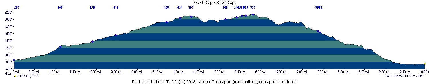
We parked at Veach Gap rd, which is just off Fort Valley rd. Park to the
right of the Gate in the small lot.
Our initial intent was to ride the entire ridge to get back to the car,
which was parked at a hiking lot at the North/East side of the ridge past
the Fish Hatchery.
The first few miles were old Jeep rd, slowly climbing until we got to a
junction of a trail which veered left. Stay Left-The Jeep rd continued to
the right as shown on the map.
None of this initial climbing was too steep, relentless once on the
singletrack, but not steep.
We climbed alongside a fire break on "Little Crease Mt" for a while on the
first long climb.
Some great views as expected once we got to the top, but even when this
place was flat it was still very technical and very tiring.
Once at the top of ridge there were only a few short but technical descents.
When you get to the big rock scramble(highest point) prepare yourself for a
very cool downhill.The trail drops off the East side of the ridge and slowly
winds down through the woods, some nice rock stairs and skinny technical
lines down to Shawl Gap. You'll see a trail marker. Go Left at the downed
tree.
The next section had me grinning from ear to ear as we descended for the
next 1.3 miles. Sometimes down large rock stairs, sometimes across the hill
gaining a lot of speed with quite a few places to catch air. Even when the
trail finally leveled out it still quite fun, always moving to keep it
interesting.
We ended up at Elizabeth Furnace-which is where you should park if you don't
want to ride back on the road.
Overall a very impressive ride, Very technical but 95% ridable if you have
the lungs and leg muscle. The place demands your attention, not many places
to relax here.
You're always looking ahead for the easiest line, a choice of which one is
less rocky.
I had 2.6" tires on my demo and was loving the extra volume, I can't imagine
riding here with a hardtail.
BEWARE, my guide tells me not many bikers use the trail so you're
essentially on your own. We didn't see anyone-not even hikers in 4 hours of
riding.
We decided not go up to Buzzard Rocks, apparently there are many "Hike a
Bike" sections there and a less impressive downhill down to the car.
Besides, I'd had more than enough fun and abuse by then.
Loops - |
| Disclaimer: Caution - Use this map at your
own risk. Bikerag.com and affiliates will not accept
responsibility for an personal injury, property damage or trespassing while
using this map. Trail users shall obey all signs, and always obtain
permission from the land owner to use trails for any sporting activity.
Permission to use trails should not be assumed. This map simply
contains topographical information and trails that existed at one time.
Trails shown maybe be missing, not accurate, closed, overgrown etc.... |