|
|
|
|
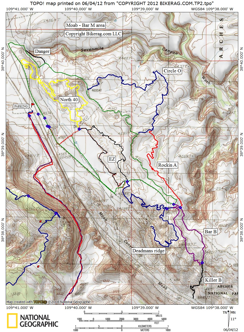
| Trail map | Map Legend |


| Moab Brand Trails - Bar m loop - Mountain Bike Trail Review with Map and Pictures | ||||||||||||||||||||||||||||||||||||||||||||||||||||
|
||||||||||||||||||||||||||||||||||||||||||||||||||||
|
MOAB Brand Trails – Review by Diana Petersen April 2012
This was a trail system that Jon and I had no interest in checking out on our many trips visiting Moab due to the beginner level rating. Because Jon was taking a day off to rest and do some work, I decided to check it out on my own. We heard that new trails had been put in the past few years, and it is well mapped with signage at every trail head so I had no worries of getting lost without having my amazing ‘trail guide’ on the ride with me. It is also a popular destination with many riders so you never feel alone for too long.
I am so glad I checked it out. The loop I did was so much fun and the 360 degree views were awesome! The beginner trails are great for families where they can teach their little ones how to pedal on dirt as well as do some sightseeing; and the higher rated trails add some fun for those who need a bit more excitement on their ride. It was the perfect active recovery day for me.
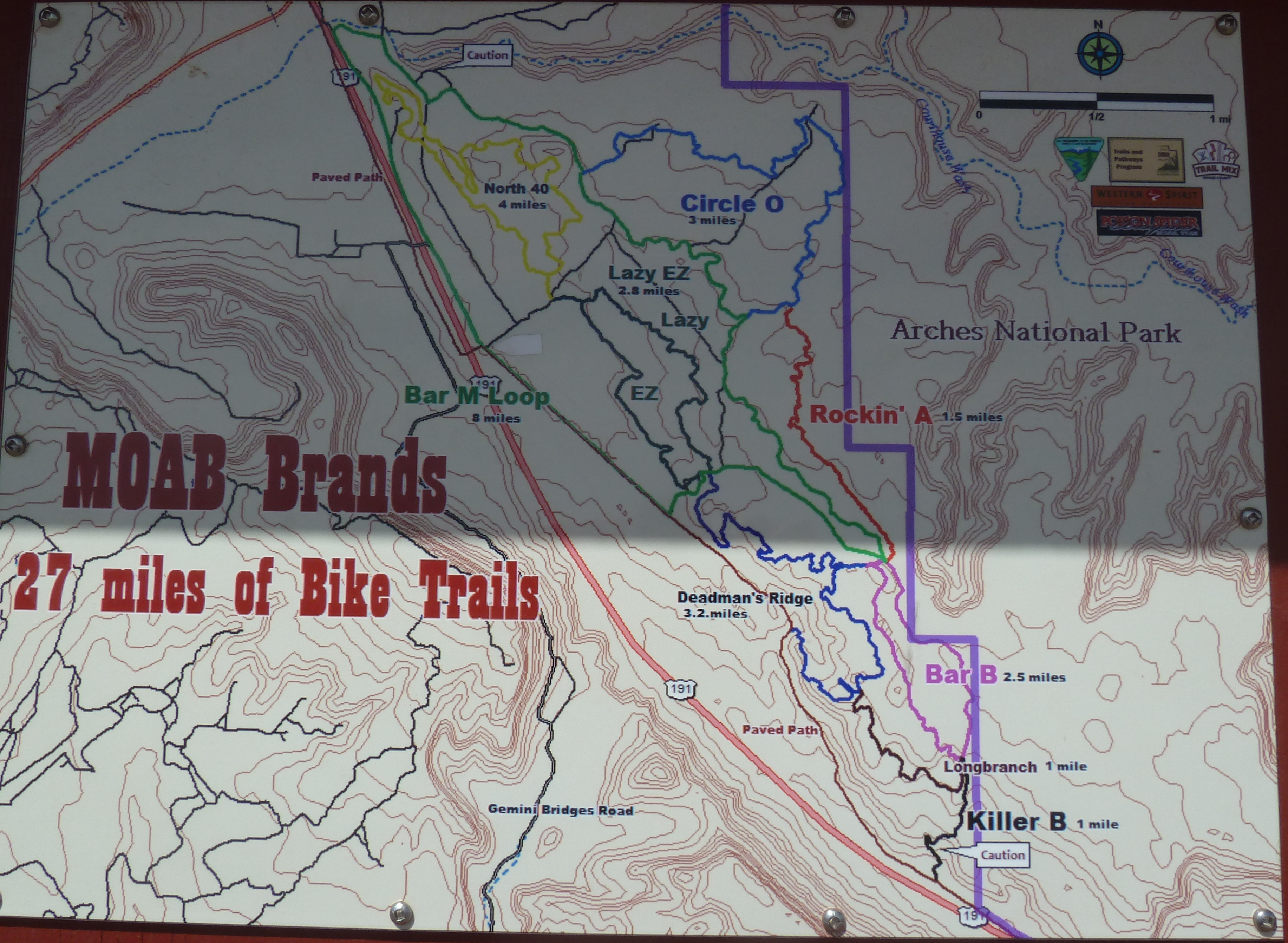
The two best intermediate / expert trails that I took are Bar B and Deadman’s Ridge. Technical with rocks, ups and downs, and mostly all singletrack except for a portion of Bar B which is fireroad. Rockin A and Circle O is all slickrock and fairly flat. It is a great intro to riding slickrock for those who have never been on it. There are paint markings for beginners to follow ensuring an easy route. For advanced riders, look around, and you’ll find some more challenging and fun lines.
My loop: From the parking lot trail head go straight. Not too far in look for a right at first map post to head south to the Lazy-EZ loop. Take next right to ride the right side of the Lazy-EZ loop. At the furthest end of the loop, you will connect with the Bar M fire road. Be sure not to take the first right off Lazy-EZ that heads down to 191. Just continue on Lazy-EZ to the top of the ridge and you will be able to see the trail head for Deadman’s Ridge across the Bar M fire road. Ride the first part of Deadman’s Ridge taking the next left to head towards Bar B. Take the right onto Bar B loop to ride the single track counter clockwise. At the southern part of Bar B, it turns to fire road. Head up hill on the fire road and when it levels out, look for a right onto Rockin A. At the end of this trail, go right onto Circle O. At the end, take a right to head towards the Bar M fire road. Cross over Bar M and look for the single track trail to North 40. At next intersection take a left on North 40 heading south. You will be able to see the lot you parked in up ahead down on the right. At the end of North 40, you will connect with the parking lot trail head. At this point you can finish the ride and go to the lot, or do as I did and continue the ride back onto the Lazy-EZ loop, taking the left leg this time, to head back to Deadman’s Ridge (my favorite trail in this system!) Once on Deadman’s Ridge I rode the entire trail all the way down to Old 191. From here you can take a left and ride back to town on the paved Old 191, or in my case I took a right and headed north back to the parking lot. |
||||||||||||||||||||||||||||||||||||||||||||||||||||
| Pre-ride Music: | ||||||||||||||||||||||||||||||||||||||||||||||||||||
| Total Miles: | ||||||||||||||||||||||||||||||||||||||||||||||||||||
| Elevation Change Feet - | ||||||||||||||||||||||||||||||||||||||||||||||||||||
|
||||||||||||||||||||||||||||||||||||||||||||||||||||
| Disclaimer: Caution - Use this map at your own risk. Bikerag.com and affiliates will not accept responsibility for an personal injury, property damage or trespassing while using this map. Trail users shall obey all signs, and always obtain permission from the land owner to use trails for any sporting activity. Permission to use trails should not be assumed. This map simply contains topographical information and trails that existed at one time. Trails shown maybe be missing, not accurate, closed, overgrown etc.... | ||||||||||||||||||||||||||||||||||||||||||||||||||||
| To
view larger version of map, right click on map and select View Image.
|
||||||||||||||||||||||||||||||||||||||||||||||||||||