|
|
|
|
| Topo Trail Map | Map Legend | Bikerag Pictures |


|
UT - Klondike Bluffs - Plus Baby Steps Singletrack- Moab - Mountain Bike Trail Review with Map and Pictures |
|||||||||||||||||||||||||||||||||||||||||||||||||||||||||||||||||||||||||||||
Directions - Its right off 191, past
sovereign.. Look for sign, drive in 2.7 miles on dirt road!! Or
ride it.. |
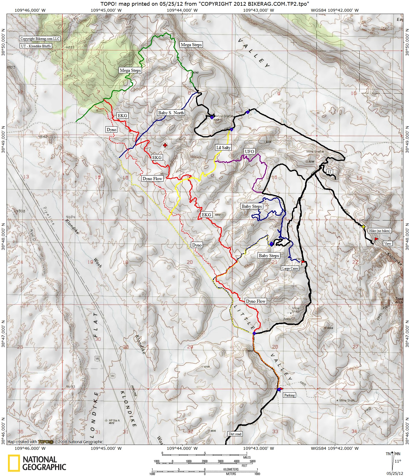
Update 2012: Some Mega improvements have been made to the Klondike area! I was hesitant to check it out but seemed worthy just for the sheer miles of trails they have recently added. The new trails include UFO, Dyno-Flow, Mega-steps and EKG. You can really put in a decent loop now at the dike! We did a moderate counter clockwise loop, Dyno flow (easy singletrack, flat), to baby steps, to UFO (not that exciting of a trail), Right on lil salty, left on fire road, nice view, to MEGA STEPS (very cool trail!, some nice flow, fun at speed), to EKG (My favorite trail here - awesome section of trail, nicely laid out), then back on dyno flow to the car. Some excellent additions to the area, my only gripe is the MEGA spray paint everywhere.. It is so TACKY.. Adventure has left the building.. Honestly, you might get confused at some point and think your at K-mart.. But still, nice trails!
Update 2006.. They have added some singletrack to this area called baby steps.. Its brandy new, but I just cant, even if I reach really really deep down into my pockets, feel the urge or any excitement to give it any kind of good review.. Indeed it IS singletrack. That in itself is enough to make some cream there pants.. There are a couple of cool sections, but for the most part its just too twisty and loose.. Not sure if more riding will make it better or worse.. Its not good for a beginner, we watched the poor girl fall all over it.. It reminds me of massebesic in new Hampshire, one of my all time low ride experiences.. It is good that they are putting in trails and getting approval (in baby steps), but in my opinion the layout of singletrack off Klondike should go something like this.. Climb the normal Klondike rock up to where it turns, then go left on singletrack winds up and down, but mainly DH back to the start.. Less sharp turns, really have to work on the banks.. You can barely even get it out of middle 1 without sliding off the trail. Our group of 6 or so riders all agreed, baby steps could be great it were completely re-routed.. Really nice area in any case.. IF you don't listen to me now, believe me later and go ride sovereign or Bartlet wash or tusher canyon after your shake the dissieness from your head and pull the red gravel from your shoes from crashing at 1.2 mph.. Ok maybe this trail IS for someone, just not sure who.. Description - Klondike bluffs or what I
like to call blonde dykes buff, is a great beginner - intermediate ride with
killer views and introduction to slickrock.. Not to mention a moderate
workout. Unless you like dirt roads, DON'T park off 191, drive you car 2.7
miles in and park at nice lot before the gate.. Loops - Its an out and back with some areas to play (with yourself). Pre-ride Music: |
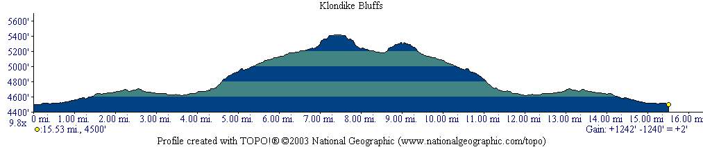
Total Miles: 25? - 1700 vertical |
|
|
Disclaimer: Caution - Use this map at your
own risk. Bikerag.com and affiliates will not accept
responsibility for an personal injury, property damage or trespassing while
using this map. Trail users shall obey all signs, and always obtain
permission from the land owner to use trails for any sporting activity.
Permission to use trails should not be assumed. This map simply
contains topographical information and trails that existed at one time.
Trails shown maybe be missing, not accurate, closed, overgrown etc.... |
To
view larger version of map, right click on map and select View Image. |
| ||||||||||||||||||||||||||||||||||||||||||||||||||||||||||||||||||||||