|
|
|
|
| Topo Trail Map | Map Legend | Bikerag Pictures |
|
UT - Grafton Mesa - Mountain Bike Trail Review with Map and Pictures |
||||||||||||||||||||||||||||||||||||||||||||||||||||||||||||||||||||||||||||||
Update 2012:
Got the word from Zion Cycles that there is a small singletrack network now
on Grafton mesa. Just the ride I was looking for. Ended up doing
a 7.5 mile loop on intermediate to expert terrain. Took the loop
clockwise which seemed to make sense. Few nice drops, rollers, some
berms and even a rock skinny and a gyno exam. Hmmm I must be in
the right place. Builders did a great job with this little network,
adding many options to the old DH line that ends down at grafton cemetery.
If you want something more epic you can combine this with the new gooseberry
north rim singletrack. Views from grafton are top notch, especially
the view of pastry ridge.. |
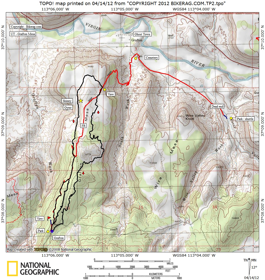
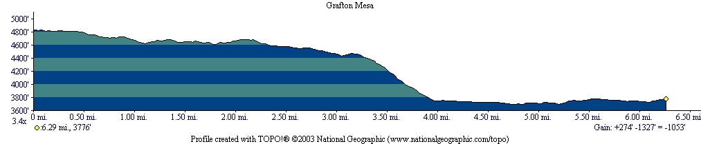
Directions - From Springdale, go west on 9 to rockville exactly 4 miles from flanigans and take left on bridge road (clear Odometer at this point) , after driving over virgin river, take right on grafton road, at road fork go left and park shuttle car on small opening by tree.. Continue traveling uphill at about 5.2 miles +/- you will see a right thats a dirt road, this leads to grafton mesa but DONT take it!! continue to mile 5.4 and take a right where you will see a 10 ' high dirt bank, see pictures.. On your bike travel up dirt road, it splits, go right and look for right on single track, hard to see.. If you kept going straight on FR, you will see open view.. Once on Single its easy to follow, there was a major right where a glimpse of trail goes straight (shown on map), work in progress?? GO right, immediate 2.85 foot drop, you hit the fire road and go left down to clearing, where trail skirts the edge.. Description - Great rocky technical single track at the top - RAW, secret trails feel, almost new england esque.. Fire road section was fun, kind of similar to porc rim, some rock, small airtime.. Killer views, unreall.. Last section started out exposed rocky slab, to boney off camber 1.5 track downhill.. Great technical skillz required, on the edge. really crazy at the end, then smooth double track red dirt off camber, fast with some techs - watch your speed.. At the bottom, look around, some cool crazy lines, then picture frame jump was right on the main road, just keep following tracks downhill through a couple wash's till you get to grafton cemetery.. Take a right, 1 mile dirt road ride back to car.. Loops - Can ride as a shuttle, OR loop, or combine with nearby gooseberry. Options are always good! Pre-ride Music: Prodigy
- The whole FAT OF THE LAND ALBUM.. |
Total Miles: 10+ miles |
|
 |
Nearest Coffee, Sushi or other food: Springdale (foot of Zion NP) Pizza Noodle 5 Stars. Good beer (Polygamy Porter). Or OSCARS - Breaksfast!! LINNER!!
|
Disclaimer: Caution - Use this map at your
own risk. Bikerag.com and affiliates will not accept
responsibility for an personal injury, property damage or trespassing while
using this map. Trail users shall obey all signs, and always obtain
permission from the land owner to use trails for any sporting activity.
Permission to use trails should not be assumed. This map simply
contains topographical information and trails that existed at one time.
Trails shown maybe be missing, not accurate, closed, overgrown etc.... |
To
view larger version of map, right click on map and select View Image. |
| ||||||||||||||||||||||||||||||||||||||||||||||||||||||||||||||||||||||