Topo Trail Map

Moab Area UT Trail Map

Map Legend Bikerag Pictures

Post a Picture and view Posted Pictures


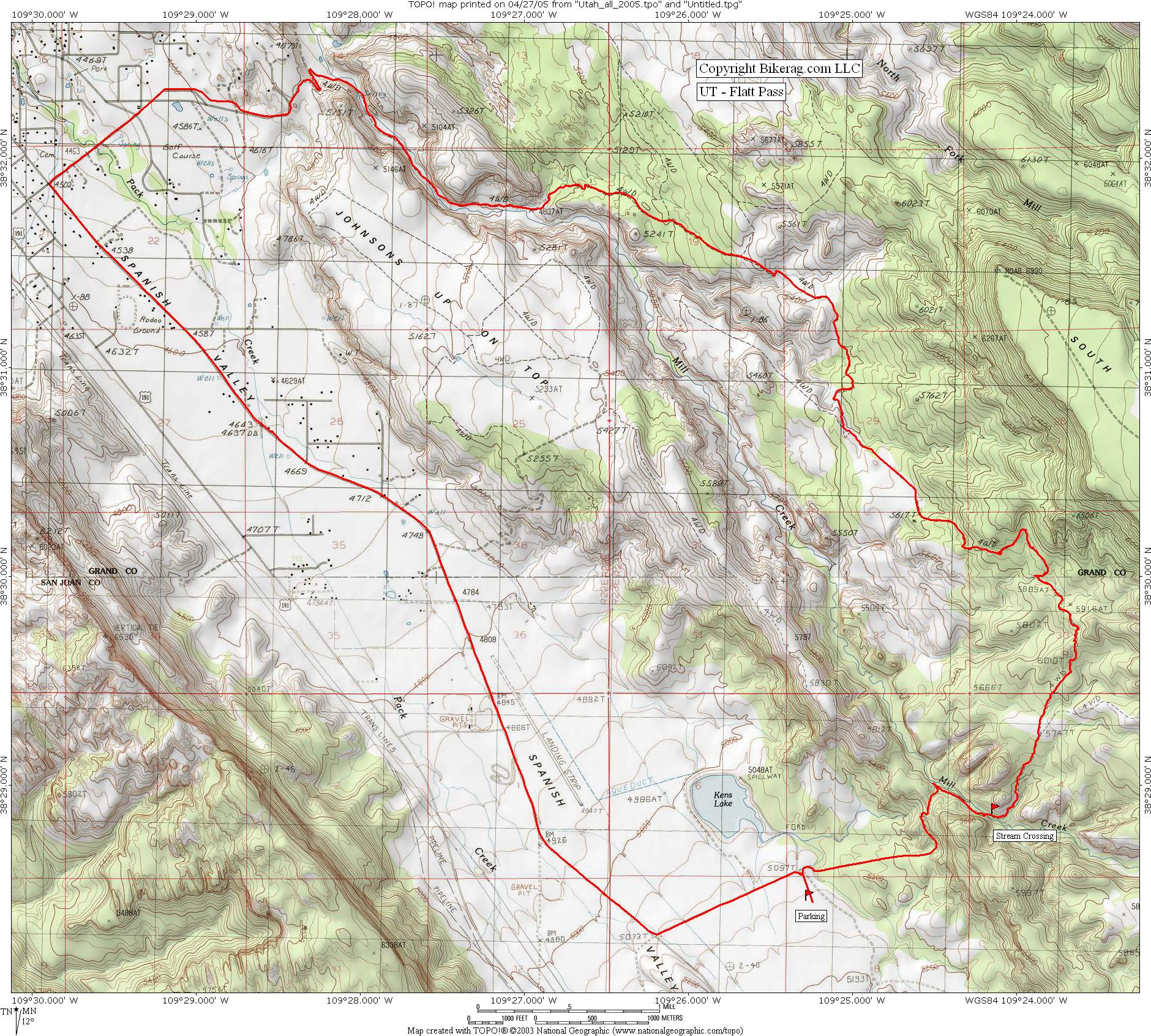
UT - Moab - Flat Pass - Steelbender Mountain Bike Trail Review with Map and Pictures

Rating Explanation (0-5)                 Category:

Overall Rating

Single-Track Adventure Climbing Free-ride Fun Fear      Trail Enhancements Scenery Technicalities
0 3 2 3 4 1 natural 4 3.9 3.85
GPS  Files - (Contact Bikerag To Upload Your files)
Google Earth GPX Map File GPX Routes Other
  flat_pass.gpx    
       
For PERSONAL use only - Please read our GPS info page
Directions - From Moab Take center to 400 east, turn left on Mill creek drive.  Mill creek goes right at stop sign, after a mile or so go left on spanish valley drive.  Take spanish valley straight for 10 miles and look for kens lake on left.  Park in first lot on right.

Description -   
I suggest starting this loop from the kens lake area. Ride up the road, past the cattle guard, and after a short descent, take a right following signs for flat pass. Check out the petroglyphs on your right.. Stream crossing beware, very slippery rocks, I suggest taking your shoes off and walking it, nice ice cream headache action but otherwise your drive train and cleats will be making SSK's hatefull chalk board noise for the best part of the trip.

Soon after your out of the stream the fun begins on nice slickrock Make sure and close the cattle gate. Lots of technical up hilling on rock, big ups, mixed in with some really nice downs.. I can see why this trail is compared to porcupine, the down hilling sections are super flowy, especially the longest one with some nice multiple drops and a few nice banked turns.. Really cool rock at the very end followed by some large smooth stone creek bed rock gardens.. On the way out you might see some hill billy dog and child walking (see pics). Back on pavement, long steep downhill followed by LONG flat pavement hell with the lasalles in the background and some cool farm animals to talk to.

Only downer of this ride was the road ride home, I hate the road, really passionately, everything about it, the yellow lines, the white lines, the barking horse size dog that almost bit my head off with a pickup driveby..

Loops -  Loop described above is good , or you might want to park at either end and to an out and back (twice the trail mileage).  Advantage of parking at the moab end would be missing the road climb at kens lake AND skipping the deep stream crossing!!!

Pre-ride Music:
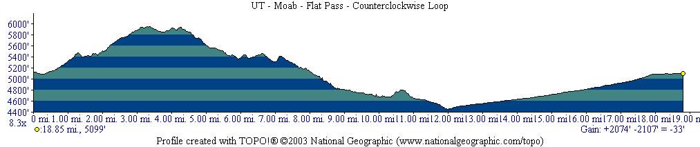
Total Miles: 19 miles, 2100 feet elevation gain
Local Bike Shops  Advertise Here !!
Lodging Temp Remove Lodging Add
Restaurants Advertise Here !!
Local Websites Advertise Here !! - Free Links may be applicable..  Just Ask..
Land Manager & other Info Contact Bikerag - To update land manager info.
Related Guide Books & Mapping Software  Mountain Bike Guide Books - Used & New

 Topo Software for all states - Used & New


Disclaimer: Caution - Use this map at your own risk.  Bikerag.com and affiliates will not accept responsibility for an personal injury, property damage or trespassing while using this map.  Trail users shall obey all signs, and always obtain permission from the land owner to use trails for any sporting activity.  Permission to use trails should not be assumed.  This map simply contains topographical information and trails that existed at one time.  Trails shown maybe be missing, not accurate, closed, overgrown etc....
 To view larger version of map, right click on map and select View Image.

Copyright by Bikerag.com, LLC.  All rights reserved.