|
|
|
|
| Topo Trail Map | Map Legend |


|
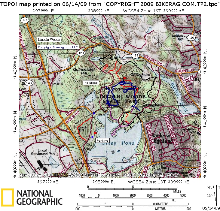
RI - Lincoln Woods - Mountain Bike Trail Review with Map and Pictures |
||||||||||||||||||||||||||||||||||||||||||||||||||||
|
||||||||||||||||||||||||||||||||||||||||||||||||||||
| Update 2009 - Its been about 9 years since Ive
checked out Lincoln woods and boy was I in for a treat! Lots of fun
rock lines, drops, rollers etc.. All in all, high speed DH fun. Directions - From CT we took Rte 2 south, to 395 north, to rte 6 East, to 295 north, to 44 east, to route 15 east (hard to find), to route 7 north, to right on Twin River Road, thru rotary, past 146 and right into the park.. But in retrospect I would just take 295 north, all the way to 146 south, then take the twin river exit left into park.. Description - Lincoln woods is a pretty small park. The acreage of parking area, picnicking & roads might be close to the area you are allowed to ride in.. In any case, the rock here is amazing. Super cool rock lines everywhere in the park - A wet dream for mr smoothie.. There are some pretty techy lines and big natural drops if you know where to look. Lots of fun lines for the kids too.. 1 footers, 2 footers, 3 footers 4 5 6 7 8.. And.. One log ride. Loops - |
||||||||||||||||||||||||||||||||||||||||||||||||||||
| Pre-ride Music: | ||||||||||||||||||||||||||||||||||||||||||||||||||||
| Total Miles: | ||||||||||||||||||||||||||||||||||||||||||||||||||||
| Elevation Change Feet - | ||||||||||||||||||||||||||||||||||||||||||||||||||||
|
||||||||||||||||||||||||||||||||||||||||||||||||||||
| Disclaimer: Caution - Use this map at your own risk. Bikerag.com and affiliates will not accept responsibility for an personal injury, property damage or trespassing while using this map. Trail users shall obey all signs, and always obtain permission from the land owner to use trails for any sporting activity. Permission to use trails should not be assumed. This map simply contains topographical information and trails that existed at one time. Trails shown maybe be missing, not accurate, closed, overgrown etc.... | ||||||||||||||||||||||||||||||||||||||||||||||||||||
| To
view larger version of map, right click on map and select View Image.
|
||||||||||||||||||||||||||||||||||||||||||||||||||||