|
|
|
|
| Rothrock Trail Map | Map Legend | Bikerag Pictures |


|
Rothrock State park (seven mountains area)- State College - PA - Mountain Bike Trail Review with Map and Pictures Preliminary Review - This place is huge |
|||||||||||||||||||||||||||||||||||||||||||||||||||||||||||||||||||||||||||||
Directions - Take 220 toward state college,
then route 322. From 322 follow signs to tussey mountain ski resort
(bear meadows road), pass the ski resort and look for rothrock parking lot
on left. |
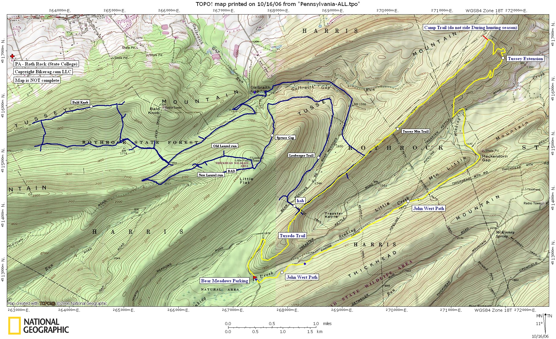
UPDATE 2006:!! There was a fire on the Tussey Mtn trail, this summer but the trail is still rideable. FYI do not use the camp trail during hunting season. New loop we hit this year was awesome, basically park at the bear lot, climb road and take right on new Tuxedo trail all rideable up to tussey mtn trail. Follow tussey to end (sweet technical ridgetop ride with nice views), take right on tussey extension (sweet downhill with one uphill section, some rock gardens & techs, off camber sidecut singletrack.), then take some roads back to John Wert path (starts wide boring, then turns wide technical, then after gas line turns tight with exspurt plus rock gardens).. Great 10 mile loop (shown yellow on map) Description - Some awesome technical riding in this gigantic state forest.. Best riding we found was on the ridges, bald knob ridge was great and the descent down maguire trail left my hands as if I spent 3 hours at the rock climbing gym with focker.. Avoid the NEW laurel run trail - its just bad, a 6" wide singletrack, littered with rocks, which is good, but as you go down it there starts to be sink holes, then a pretty good mandatory washout hike a bike down.. Spruce gap trail wasnt that great either, it was steep, but mainly just wide open loose trail.. Lonberger path was nice buff singletrack with some enhancements - FAST.. Tussy mountain was great rock riding once again but the filmore down was weak - fall line DH is such a waste of vert. Bottom of the trail was fun with some nice log drops.. Still a great ride all in all.. Next time, and there will be a next time, I plan to hit the old laurel run trail, ride the whole tussey mountain trail with jeep trail down that I found on my topo, and the john wert path.. Loops - Check out cyclesa.com for loops, they do a great job.. I followed there intermediate loop (well pretty much), except a diversion here and there.. More stuff on loops from Jack!! 10ish miles, fun and technical. (Clockwise loop on map). Tussey - Tussey extension. Focking sweet. John Wert. Holly sheit rocky flat. Bring slow handling skills. 25ish miles, climbing, DH, fireroad, steepish DH, climbing, nice DH. (Figure 8 loop on map). Snowmobile. Doublewide to access telephone. Moderate climbing. Telephone. A stiff-moderate climb. A little bushwacking. Ross. Really fun until you get to the fence. One really steep section. Some jumps, rocks, and logs make it interesting. Rough Gap. Steep and tech in spots. Crashing is likely, but the trail is cleanable. 1000 foot/mile DH steep slow crawler. Sassafras. A moderate but steady climb. Nice trail. Pig Pile. Starts with a fairly easy climb, then sone nice techs on the ridge. Ends with fast wide DH. 10-11 miles that sucked. (Counter-Clockwise loop on map). Road to Penn Roosevelt, then connect to Long Mtn trail. This one sucks ass. It's purple on the tpo file I'm including. Long section of road, then a little nice climbing, then a steep hike-a-bike with lots of blow downs, then some decent singletrack except too short with many blow downs. When the trail finally opens up, it opens to doubletrack. Similar to your ride around Bald Knob, McGuire, except we did Old Laurel Run and out-and-backed Longberger. Old Laurel Run. Fun riding type DH where you get something for your climbing effort. Not an overly steep crawler where you waste your altitude. Rocks and small jumps along the way. Awesome Epic! Old laurel road, bald knob, McGuire, old laurel run, three bridges, longberger, kettle, tussey, tussey extension, john wert, longberger. This is about 25ish miles and hits the best trails in Rothrock. I did not actually ride this as one continuous loop, but it would be stellar. Pre-ride Music: |
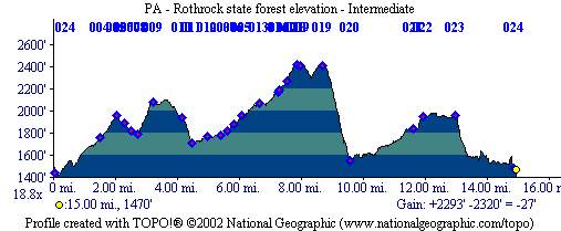
Total Miles: Our loop was 15, but here there
is like 150 or so?? |
Elevation Change Feet - 2300 |
|
Disclaimer: Caution - Use this map at your
own risk. Bikerag.com and affiliates will not accept
responsibility for an personal injury, property damage or trespassing while
using this map. Trail users shall obey all signs, and always obtain
permission from the land owner to use trails for any sporting activity.
Permission to use trails should not be assumed. This map simply
contains topographical information and trails that existed at one time.
Trails shown maybe be missing, not accurate, closed, overgrown etc.... |
To
view larger version of map, right click on map and select View Image. |
| ||||||||||||||||||||||||||||||||||||||||||||||||||||||||||||||||||||||