|
PA - Prompton - Mountain Bike Trail Review with Map and Pictures |
||||||||||||||||||||||||||||||||||||||||||||||||||||||||||||||||||||||||||
Directions - Its sooooo easy to find..
Just get to rte 6, from CT take rte 84 through New York, old exit? #8 on rte
402 north, left on rte 6, through hawley, honesdale, 5 miles past honesdale
look for rte 170 north, drive 1/2 mile and take a right into parking area.. |
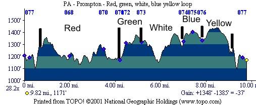
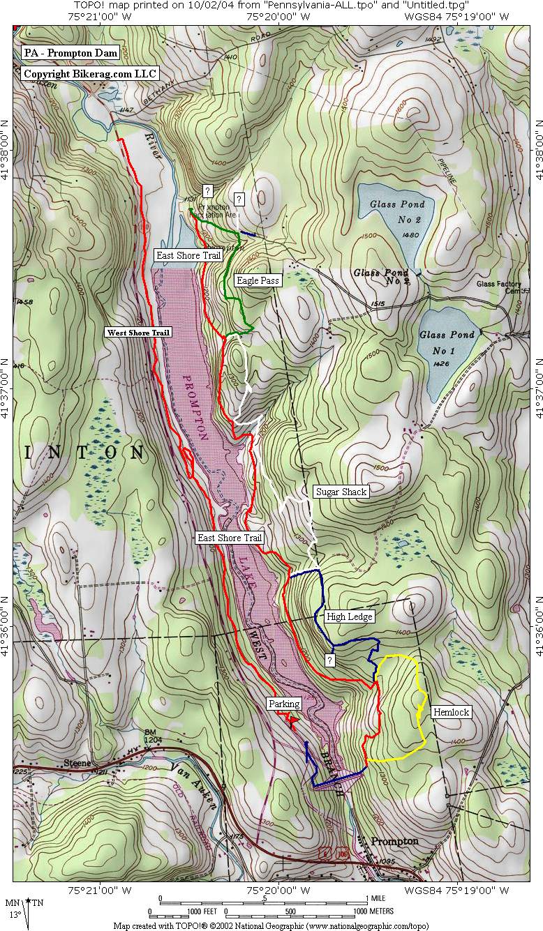
Description - Prompton State Park was a pleasant surprise for the tail end of our Mid-Atlantic mountain bike tour.. We headed to Honesdale first to get a map at Northeast sports located next to CVS off route 6.. After getting the skinny on this little sliver of land, we headed out on the red by first riding up on the dam.. Right out of the gate you get a nice view of the area..FAAAANtastic.. Just keep going straight at the end of the wide pea gravel road and you will be thrown into a 20 foot climb followed by a gonzo rock garden.. The route we took was out on red and back on green, white, blue, yellow for a 10 mile loop.. We skipped the red on the west side of the lake due to time constraints.. The trails contained a huge variety of conditions and obstacles.. Every stream crossing was lined like a palace with flat ride able rocks that you could cruise at speed.. I would say the trail system was 95% single-track that has not been ruined by over-use.. Great rock gardens and some roots were the norm.. There was a wicked cool stone wall ride with real consequences and a 2 foot gyrating dismount that I contemplated for 5 minutes.. Other stuff we found was a couple whoopty doos, big up hill log pyramid, couple log beds, one new log ride (ok I think its a bench), and some semi switch backy S-turn sections.. Also note-able are sections of semi rocky singletrack through open fields that reminded me of Judy springs on spruce knob (WV), and some off camber stuff.. The vibe of this place was great although there were no spectacular views atop 5000 foot mountains.. Terrain was very flowing and ever changing.. As you traveled north on the red trail you could see glimpses of the lake on your left.. Also lots of hanging vines and stone walls.. Even rode about 100 feet with some deer.. Nothing Gonzo here, all ride-able, my hands are sore, but that's probably beside the point.. I even dabbed a couple times.. Come here and ride, play a round of frisbee golf when your finished or drive to Honesdale for some carbo-loading.. I will be back! Pre-ride Music: MC 900
Ft Jesus - Welcome To My Dream |
Total Miles: 14 plus |
Elevation Change
|
| ||||||||||||||||||||||||||||||||||||||||||||||||||||||||||||||||||||||


