|
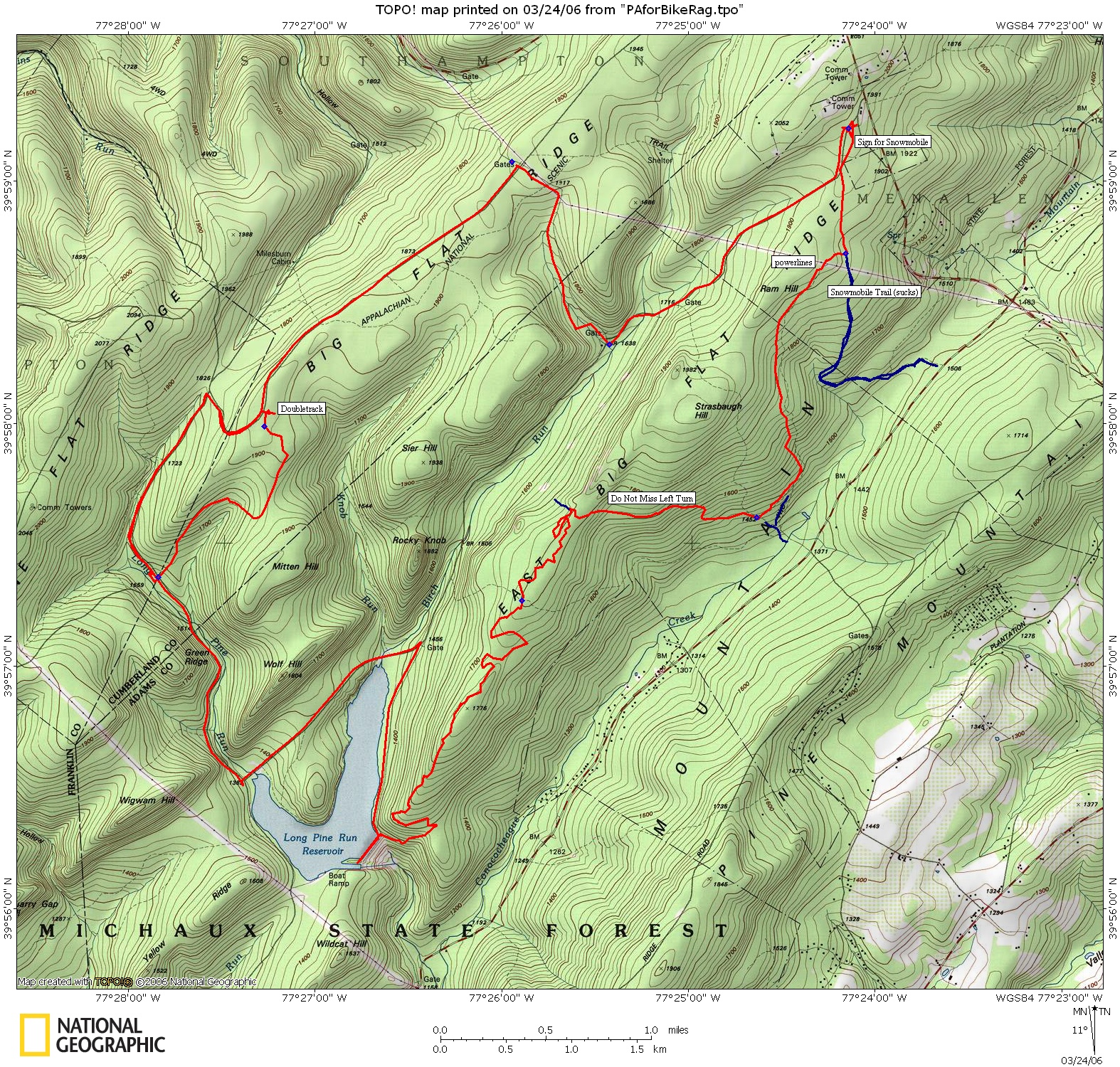
Flat Rock Shared-Use Trail. Get the map the forest service provides
(from
pine grove furnace). The numbers I marked correspond to the map
numbers.
However, the map is in error so x-ref with my map. These trails are
NOT
ATV, they are bike, hike, and horse. It starts in the
ATV/Snowmobile/Flat
Rock parking area of Shippensburg road. Begin on the snowmobile trail
out
of the parking area. When you reach intersection 1, go right.
Cross under
the power lines. The trail is blazed with red paint. After some
flats
you'll head downhill. Fast and loose with some baby jumps. Just
before
hitting the road the trail will fork and head right (uphill). Get your
climbing legs ready. Follow the trail until it hits doubletrack, then
climb
the doubletrack, but keep an eye out for a singletrack on your right.
I
think this is where #2 is. Now, the climbing gets tougher, but I only
had
to push one short section because it was really loose. The climb will
top
out and you will ride almost through a campsite. Just past the
campsite the
trail goes downhill. WATCH YOUR SPEED or you will miss the quick left
that
switches back towards the campsite. The trail looks like it just goes
to
the campsite, but if you take it, you will find red blazes and some fine
singletrack. The next few miles are a excellent mix of tech, climbs,
narrow
lines, rocks, and downhill. You will cross a doubletrack midway which
will
have a #17 marker. The trail ends near the lake and is at least as
good as
the 3 mile trail, if not better. You can ride across the dam, but it
does
not link up to the other side. Ride the road around the lake, taking a
left
at the gate, then go another mile or so, then go right. Climb this
dirt
road past #8 and ride towards #10. Prior to #10 is a doubletrack which
you
take a short distance then take the first right onto singletrack, then take
a left at #10 (another singletrack goes right). The trail between #10
and
#8 is fun, but not terribly long or rocky. There is one sketchy jump
midway
down where I damned near crashed into the huge ant hills that are common in
the area. The jump is not large, but the landing is loose. After
you get
back to the road climb and the follow the map.
Loops - |
| Disclaimer: Caution - Use this map at your
own risk. Bikerag.com and affiliates will not accept
responsibility for an personal injury, property damage or trespassing while
using this map. Trail users shall obey all signs, and always obtain
permission from the land owner to use trails for any sporting activity.
Permission to use trails should not be assumed. This map simply
contains topographical information and trails that existed at one time.
Trails shown maybe be missing, not accurate, closed, overgrown etc.... |