|
|
|
|
| Topo Trail Map | Map Legend |


|
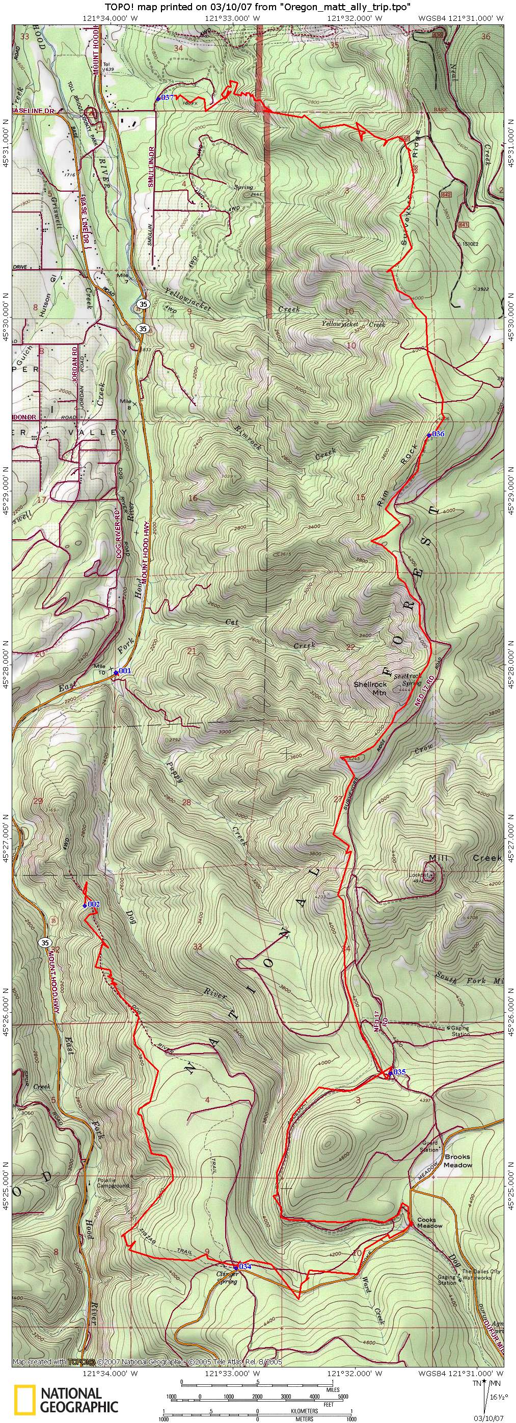
Dog River – Surveyor’s Ridge – Oakridge Trail Mountain Bike Trail Review with Map and Pictures - Reviewed By NB & HLM |
|||||||||||||||||||||||||||||||||||||||||||||||||||||||||||||||||||||||||||||
Directions - This was done as a shuttle
but each portion can be done as an out and back. To get to the Oakridge
Trail, take Highway 35 South into community of Mt Hood (approx 15 miles).
Just past the Hood River Ranger Station and Country Store, take the first Lt
onto Sutton. As the road goes right, take the dirt road to the left to the
trailhead. Leave a vehicle for the finish. |
Go back to Highway 35 South and travel south about 5 more miles. Look for a gravel parking lot with a trailhead on the left. This is the start of the Dog River Trail. Description - Dog River is hard packed, pine needle singletrack that climbs up about 2,00ft over 6.3 miles- a fairly easy grade. There are ponderosa pines and great views of the glacier-carved Mt Hood. All rideable except one very small section. Surveyors Ridge is 11.7 miles of hard-packed buff singletrack that rolls along a ridge line that offers spectacular views of Mt Hood and the valley. There are steep ups and downs as well as flat sections. Nothing technical. Oakridge Trail is approximately 4 miles of fast fun downhill singletrack. There is an open meadow towards the end with lots of tight switchbacks that are quite challenging. Again nothing technical by CT standards! Loops -Up Dog River Trail until you reach the parking lot where Surveyor’s Ridge Trail starts. Take that trail following the signs- there is only one major turn to the left and it’s well marked. Take until junction of Oakridge Trail which is a left. Follow till end where your vehicle awaits. Pre-ride Music: |
Total Miles: 21 |
Elevation Change Feet - |
|
Disclaimer: Caution - Use this map at your
own risk. Bikerag.com and affiliates will not accept
responsibility for an personal injury, property damage or trespassing while
using this map. Trail users shall obey all signs, and always obtain
permission from the land owner to use trails for any sporting activity.
Permission to use trails should not be assumed. This map simply
contains topographical information and trails that existed at one time.
Trails shown maybe be missing, not accurate, closed, overgrown etc.... |
To
view larger version of map, right click on map and select View Image. |
| ||||||||||||||||||||||||||||||||||||||||||||||||||||||||||||||||||||||