|
|
|
|
| Topo Trail Map | Map Legend | Bikerag Pictures |
|
NY - Vassar Farms - Mountain Bike Trail Review with Map and Pictures |
||||||||||||||||||||||||||||||||||||||||||||||||||||||||||||||||||||||||||||||
Update
2008: - I hear lots of the Trail features are gone and the BMX stuff
was bulldozed! |
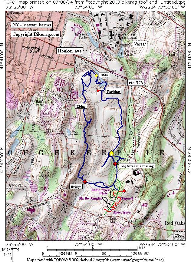
Directions - From Poughkeepsie take hooker ave (rte 376) east until it intersects with raymond ave (on left) and take a RIGHT onto DIRT road (vassar farms), go past pond, to farm buildings and park in lot.. Trailhead is back at the pond you passed, starting in BMX area.. Description - If your in the area this is a decent place to check out.. Starts with single track and immediately puts you in the BMX dirt jump area, then TWISTY singletrack, there are many trails, you may ride around in circles, we got lucky and didnt, found our way to a stream where we took a right and got on the ridge trail.. Keep following the map and you will eventually find some really nice short labeled loops with some trail enhancements.. Be carefull, some high bridges in here, super super fun stuff, something for everyone, 1 foot high to 12 foot nose bleeders.. Couple hucks, couple log rides, one see saw.. Good 2 hour ride if you hit everything.. Look for trails like Blair, radio flyer, Armageddon, super 8, my Bo jangles and more.. Pre-ride Music: |
Total Miles: 7.5 +/- |
Elevation Change Feet - Pretty dam flat, maybe
400 vertical |
|
|
Disclaimer: Caution - Use this map at your
own risk. Bikerag.com and affiliates will not accept
responsibility for an personal injury, property damage or trespassing while
using this map. Trail users shall obey all signs, and always obtain
permission from the land owner to use trails for any sporting activity.
Permission to use trails should not be assumed. This map simply
contains topographical information and trails that existed at one time.
Trails shown maybe be missing, not accurate, closed, overgrown etc.... |
To
view larger version of map, right click on map and select View Image. |
| ||||||||||||||||||||||||||||||||||||||||||||||||||||||||||||||||||||||