|
|
|
|
| Beebe hill - Trail map (preliminary) | Map Legend |


|
|
|
|
| Beebe hill - Trail map (preliminary) | Map Legend |
| Beebe Hill - Austerlitz NY Mountain Bike Trail Review with Map and Pictures | ||||||||||||||||||||||||||||||||||||||||||||||||||||
|
||||||||||||||||||||||||||||||||||||||||||||||||||||
|
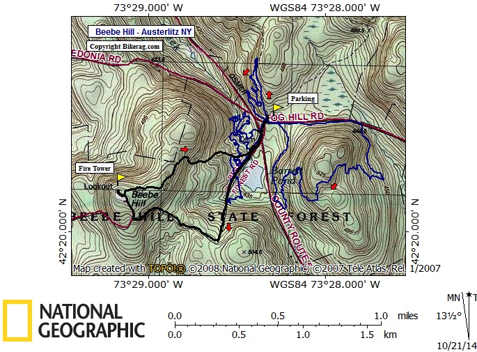
Directions - Just google fog hill rd in Austerlitz NY, then use the topo map. If your headed out on the mass pike, its not far at all off the beaten path. Description - This is a singletrack trail system built by local mountain bikers. Really nice flowy trails that certainly use the natural terrain to the fullest extent. Some technical rocks mixed in with the occasional log ride or drop give this place some variety and character. The bowl areas are very cool with some chris cross lines of gravely singletrack carved very creatively. The ride up to the firetower is a workout, but worth the view if your willing to climb up with already sore legs. Trip down on some existing trails was decent, but not as good as the mountain biker built trails to say the least. Locals are super cool and friendly, gave us a nice tour, you can find them on FB (Columbia County Mountain Bike Alliance). Loops - |
||||||||||||||||||||||||||||||||||||||||||||||||||||
| Pre-ride Music: | ||||||||||||||||||||||||||||||||||||||||||||||||||||
| Total Miles: 8.24 miles 1,000 vertical so far | ||||||||||||||||||||||||||||||||||||||||||||||||||||
| Elevation Change Feet - grand | ||||||||||||||||||||||||||||||||||||||||||||||||||||
|
||||||||||||||||||||||||||||||||||||||||||||||||||||
| Disclaimer: Caution - Use this map at your own risk. Bikerag.com and affiliates will not accept responsibility for an personal injury, property damage or trespassing while using this map. Trail users shall obey all signs, and always obtain permission from the land owner to use trails for any sporting activity. Permission to use trails should not be assumed. This map simply contains topographical information and trails that existed at one time. Trails shown maybe be missing, not accurate, closed, overgrown etc.... | ||||||||||||||||||||||||||||||||||||||||||||||||||||
| To
view larger version of map, right click on map and select View Image.
|
||||||||||||||||||||||||||||||||||||||||||||||||||||