|
|
|
|
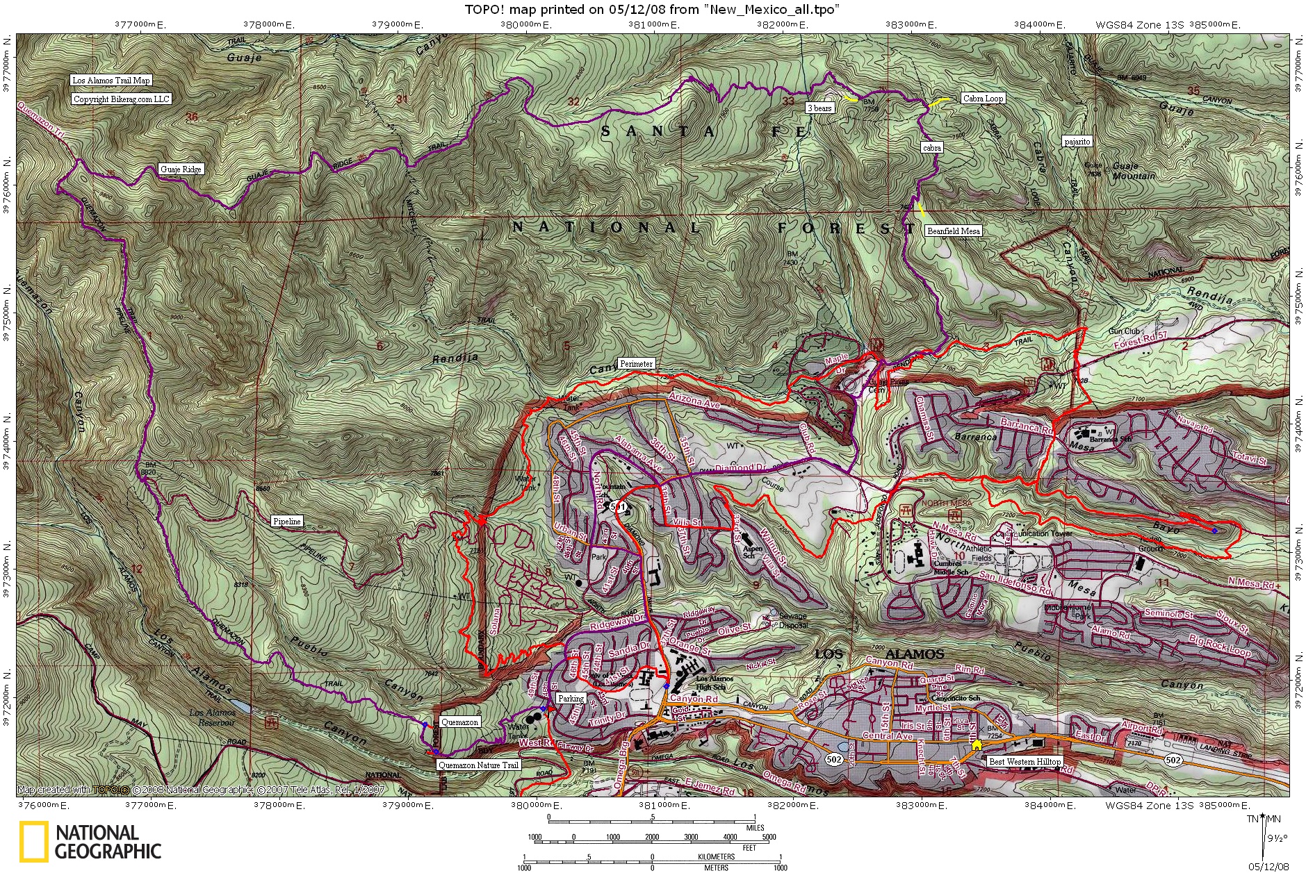
| Trail map | Map Legend |


| Quemazon Trail, Quemazon nature trail, Pipeline, Guaje Ridge, Cabra - Los Alamos, New Mexico - Mountain Bike Trail Review with Map and Pictures | ||||||||||||||||||||||||||||||||||||||||||||||||||||
|
||||||||||||||||||||||||||||||||||||||||||||||||||||
| Directions - This ride starts right in town so
you can either start from your hotel, or drive to the Quemazon trailhead..
Trailhead is not well marked, but if you head down trinity, cross diamond,
its about your 3rd left, almost looks like a driveway, but look for the big
water tanks..
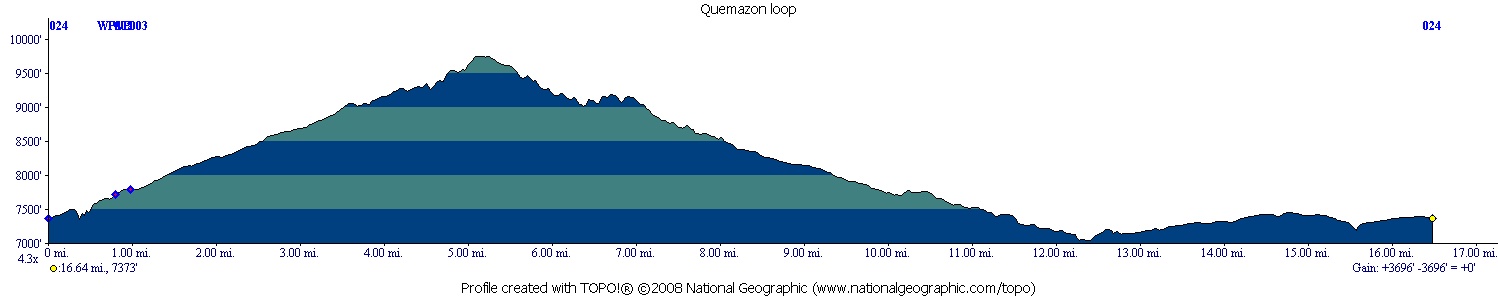
The map I posted here is pretty good but does not show all trails, I suggest you pick up the santa fe - los alamos map by sky terrain. Description - Holy crap balls this was a fun and demanding loop.. Starting at Quemazon trailhead we ended up taking our first left on singletrack off the wide trail. You hit another road pretty quickly, take a right, uphill, then left on Quemazon nature trail (marked with green #'s).. The Q. Nature trail / Quemazon trail was sweet, all uphill, all rideable technical singletrack mostly made up of rock slabs. Nothing gonzo, but constant technical moves for 3.5 miles.. Would be fun as hell to go down, but we had bigger fish to fry. Even found a pretty sweet log ride or 2 on the way up. If you take the nature trail, there is one fork where you should bear right, then pretty shortly after that you hit the Quemazon trail and take a left to continue uphill.. OH, one note for any out of towners, the entire climb and most of the decent is totally exposed due to the fire in 2000. Once you hit the pipeline, the trail turns into fire road and continues as such all the way to guaje ridge. Scenery is amazing, great view throughout the whole ride. At the top you pop into some trees at the start of Guaje Ridge, but only for a short time before the trail is exposed again. Trail is nice bench cut singletrack with some slight exposure in places. There are some uphill sections but few and far between, the trail is generally downhill all the way to cabra. The guaje ridge trail ranged from bench cut singletrack to buff singletrack to fun techy rock slabs with a few semi gnarly sections. The fun seemed never ending. On Guaje Ridge you will pass The Mitchell trail on your right, and eventually run into a dirt road "T" after several miles. At the T, 3 bears is right, take a left to continue on to cabra. Next intersection was a little confusing, there was a singletrack straight and one that forked to the right. We took the right fork which ended up being cabra, I assume the straight was cabra loop.. Cabra was very cool, nice singletrack with some cool views and interesting rock formations as the trail eventually dropped into the valley. At the bottom we took a right on Rendaja and eventually found our way to a road for the trip back to quemazon trailhead. There are many trails you can take around town on the route home to extend your loop too. This is one of the best rides I have ever done, top 5 for sure! Loops - |
||||||||||||||||||||||||||||||||||||||||||||||||||||
| Pre-ride Music: | ||||||||||||||||||||||||||||||||||||||||||||||||||||
| Total Miles: 16 | ||||||||||||||||||||||||||||||||||||||||||||||||||||
|
Elevation Change Feet - 3696
|
||||||||||||||||||||||||||||||||||||||||||||||||||||
|
||||||||||||||||||||||||||||||||||||||||||||||||||||
| Disclaimer: Caution - Use this map at your own risk. Bikerag.com and affiliates will not accept responsibility for an personal injury, property damage or trespassing while using this map. Trail users shall obey all signs, and always obtain permission from the land owner to use trails for any sporting activity. Permission to use trails should not be assumed. This map simply contains topographical information and trails that existed at one time. Trails shown maybe be missing, not accurate, closed, overgrown etc.... | ||||||||||||||||||||||||||||||||||||||||||||||||||||
| To
view larger version of map, right click on map and select View Image.
|
||||||||||||||||||||||||||||||||||||||||||||||||||||