|
|
|
|
| Ramapo Trail map link | Map Legend |


| Ramapo Mountain - Mountain Bike Trail Review with Map and Pictures | ||||||||||||||||||||||||||||||||||||||||||||||||||||
|
||||||||||||||||||||||||||||||||||||||||||||||||||||
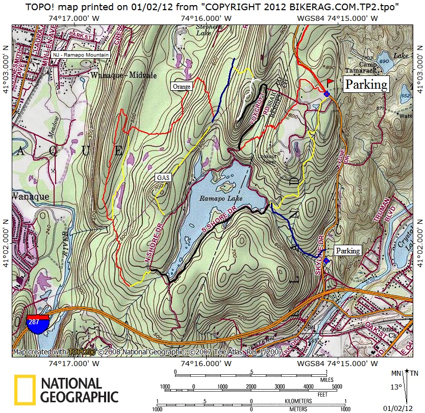
| Directions - 287 to Skyline drive, Park at the
lot on top, if you can find a space! Description - The infamous G-string has been telling me to check out Ringwood / Ramapo for some time now. Not sure what my excuse is, its almost too close to home for a trip? Tapanzee traffic Anxiety? In any case, finally pulled the trigger and had a great ride following the suggested route from Jorba. There had to be 100 cars in the lot when we arrived yet only saw a few people on the trail. Headed out red white to cannonball trail switchbacks. Great rock lines, singletrack, technical.. Switchbacks were moderately challenging, and really nicely laid out. We pedaled up the road to see the Castle Ruins - very cool site with nice views! Even a nice double foundation rock skinny with view to a kill.. Sweet.. Down white to gas line, look for somewhat un-marked trail (faint red dot), takes you to blue to Orange. Orange was a mixed bag, Mainly crappy ATV rutted double, 5 or so hike a bikes, BUT awesome ridge line section with amazing top of the world view.. Yellow on the way back home was awesome, nice technical climb, had some teeny jumps pointing the other way.. Loops - |
||||||||||||||||||||||||||||||||||||||||||||||||||||
| Pre-ride Music: | ||||||||||||||||||||||||||||||||||||||||||||||||||||
| Total Miles: | ||||||||||||||||||||||||||||||||||||||||||||||||||||
| Elevation Change Feet - | ||||||||||||||||||||||||||||||||||||||||||||||||||||
|
||||||||||||||||||||||||||||||||||||||||||||||||||||
| Disclaimer: Caution - Use this map at your own risk. Bikerag.com and affiliates will not accept responsibility for an personal injury, property damage or trespassing while using this map. Trail users shall obey all signs, and always obtain permission from the land owner to use trails for any sporting activity. Permission to use trails should not be assumed. This map simply contains topographical information and trails that existed at one time. Trails shown maybe be missing, not accurate, closed, overgrown etc.... | ||||||||||||||||||||||||||||||||||||||||||||||||||||
| To
view larger version of map, right click on map and select View Image.
|
||||||||||||||||||||||||||||||||||||||||||||||||||||