|
|
|
|
| Topo Trail Map | Map Legend | Bikerag Pictures |


|
NH - Ridgepole Trail - Mountain Bike Trail Review with Map and Pictures |
|||||||||||||||||||||||||||||||||||||||||||||||||||||||||||||||||||||||||||||
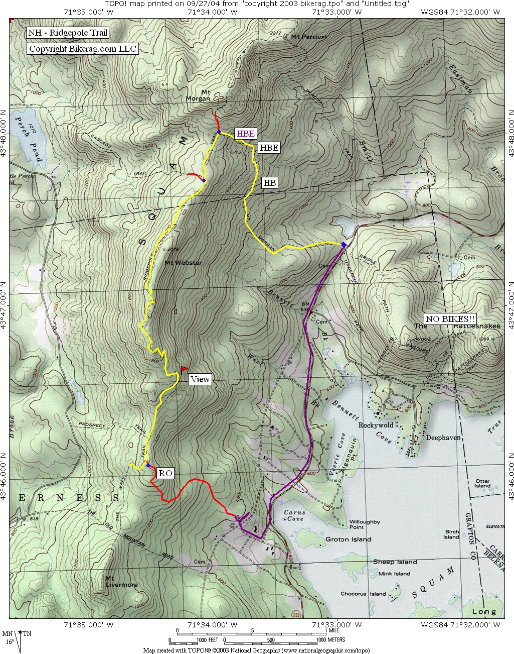
Directions - From Route 93, take exit 24,
route 25 east, to 113 east (clear odometer), travel 5.5 miles and look for
pedestrian sign, park on left. You might want to investigate parking
in a different location and taking a better trail up to the ridgepole, LOTS
of hike a bike on the Morgan trail.. |
Description - Good uphilling followed by extreme hike a biking on the Mt. Morgan trail.. Once your on the ridge, its lots of up and down with some techs, couple wet sections but not too bad.. All singletrack.. Once the trail starts descending, it doesn't, it goes back up, this happens about 5 times before it finally hits a super sweet long decent, with killer views of Squam Lake, really good trail, mildly technical, fun, some good switchbacks.. 2 drops, one 1.5 footer and one 6 incher, that's all I found.. We took a left off the ridgepole on the red orange trail.. Followed it down to some tennis courts where the trail diminished, mild bushwhack to road that goes to 113.. Emailed Information in response to bikerag Review - THANKS Mark!!!
Just noticed your review of the Ridgepole
ride in NH. Learned to puke on that ride starting many years ago.
You missed the real puke-inducer though. LIVERMORE!
If your in the area again start your ride on
the left side of the road, after the sharp right turn, just past the
sign for Cotton Cove (on 113). Ride in for 1/2 mile or so of single
and double-track, bear left at the split and then go left at the
sign for LIVERMORE. Climb until you puke. Descend for a short bit
and bear right at the trail sign. Climb the satanic switchback until
you dry-heave, all the way to the top. Spectacular of Squam and a
glimpse of Winna-pa-suck-me. Descend the backside of LIVERMORE and
star the long climb up the Ridgepole. Continue to sign for Cascade
trail. Turn around and enjoy the next half hour plus of downhill.
Avoid the Mt. Morgan Trail. No good at all going up (as you
discovered) and not worth the down (vs. the Ridgepole).
The inclusion of LIVERMORE really "makes" the
ride, especially if you enjoy a good beatdown.
Loops - Pre-ride Music: |
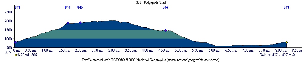
Total Miles: 8.5 miles Plus |
Elevation Profile - 1600 Vertical |
|
Disclaimer: Caution - Use this map at your
own risk. Bikerag.com and affiliates will not accept
responsibility for an personal injury, property damage or trespassing while
using this map. Trail users shall obey all signs, and always obtain
permission from the land owner to use trails for any sporting activity.
Permission to use trails should not be assumed. This map simply
contains topographical information and trails that existed at one time.
Trails shown maybe be missing, not accurate, closed, overgrown etc.... |
To
view larger version of map, right click on map and select View Image. |
| ||||||||||||||||||||||||||||||||||||||||||||||||||||||||||||||||||||||