| Directions - Your best bet is to go to
littletonbike.com, and ask
for directions or hook up with a group ride.. Also
littletonlandsharks.com Description - Littleton
has an awesome mountain bike community, the local bike shop is HUGE and
filled with really nice people.. We checked out 2 rides, more dam
trail I assume is the least secretive of the Littleton trails. Its a
3.5 mile out and back, that follows the Moore reservoir shoreline..
Its an interesting ride, lots of functional bridges and a few skinnies to
keep you out of the mud, along with some buff singletrack and quite a few
technical moves.. Its very flat, but some steep ups and downs..
2nd ride was parker - sweet ride, technical singletrack, decent climb,
awesome decent.. Best bet is to hook up with locals, or have one of
the mechanics draw you a map on a napkin.. Loop we did was 8 miles,
perfect mix of trail, from twisty, to technical, to some nice flowing
sections.
Thanks to all the local riders that seem to do an AMAZING amount of
trail work...
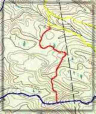
Loops - |
| Disclaimer: Caution - Use this map at your
own risk. Bikerag.com and affiliates will not accept
responsibility for an personal injury, property damage or trespassing while
using this map. Trail users shall obey all signs, and always obtain
permission from the land owner to use trails for any sporting activity.
Permission to use trails should not be assumed. This map simply
contains topographical information and trails that existed at one time.
Trails shown maybe be missing, not accurate, closed, overgrown etc.... |


