|
|
|
|
| Bikerag Trail map
(Incomplete) Map And Info link - Great Trail Map |
Map Legend |


|
|
|
|
| Bikerag Trail map
(Incomplete) Map And Info link - Great Trail Map |
Map Legend |
|
NH - Cornish Town Forest Review - Mountain Bike Trail Review with Map and Pictures
Preliminary Review -1 quick ride |
||||||||||||||||||||||||||||||||||||||||||||||||||||
|
||||||||||||||||||||||||||||||||||||||||||||||||||||
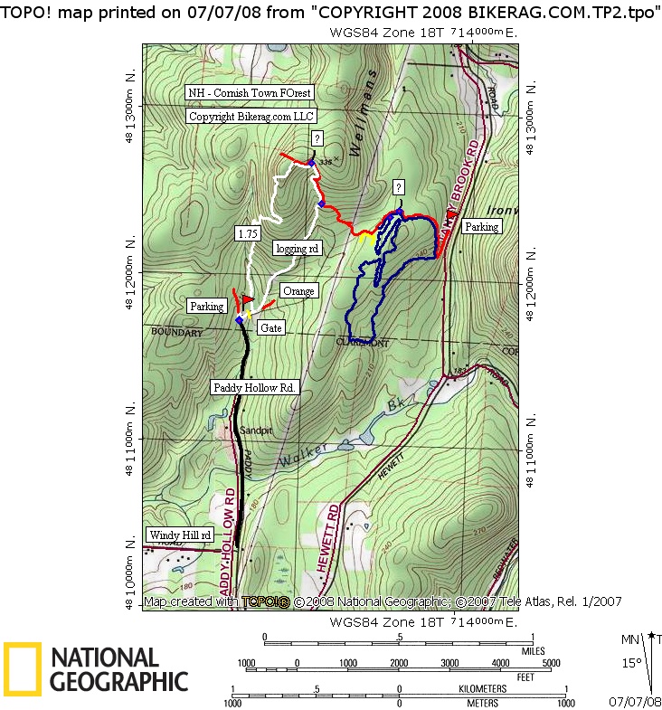
| Directions - From route 91 in Vermont
take exit 8 (Ascutney) and head east on 131. After a short distance on
131 head on 12 south for .9 miles, then take left on 12a north. Travel
1.2 miles and look for right on windy hill road (shown as punkshire hill
road on older maps). Top of punkshire take left on paddy hollow road
(dirt, SUV may be required depending on road conditions).. Parking
area is about at .8 miles in where there is a small grass parking area, and
gate. Description - Some pretty nice singletrack in this area that seems to be very mountain bike friendly. Some moderate technicalities on blue and white, all singletrack, good flow! Avoid when wet. Trails were very well marked, and we did see a couple singletracks off the red trail that were not marked.. Next time.. Next time.. Getting into the trail system was a little problematic, but doable. We took the 1.75 mile white trail that had some hike a bike on it.. Nothing gonzo, but I have to assume there is a better way up, and then you can take the 1.75 mile white down at the end of the ride. I would suggest climbing the wide class 4 grassy logging road shown white on the map. Boring climb but less hike a bike. Another option would be to take the red trail to the top, not sure if thats any better than the 1.75 mile white. Take the blue trail clockwise - had some good flow. Next time ill be sure and check out the orange and yellow loop. Loops - |
||||||||||||||||||||||||||||||||||||||||||||||||||||
| Pre-ride Music: | ||||||||||||||||||||||||||||||||||||||||||||||||||||
| Total Miles: | ||||||||||||||||||||||||||||||||||||||||||||||||||||
| Elevation Change Feet - | ||||||||||||||||||||||||||||||||||||||||||||||||||||
|
||||||||||||||||||||||||||||||||||||||||||||||||||||
| Disclaimer: Caution - Use this map at your own risk. Bikerag.com and affiliates will not accept responsibility for an personal injury, property damage or trespassing while using this map. Trail users shall obey all signs, and always obtain permission from the land owner to use trails for any sporting activity. Permission to use trails should not be assumed. This map simply contains topographical information and trails that existed at one time. Trails shown maybe be missing, not accurate, closed, overgrown etc.... | ||||||||||||||||||||||||||||||||||||||||||||||||||||
| To
view larger version of map, right click on map and select View Image.
|
||||||||||||||||||||||||||||||||||||||||||||||||||||