|
|
|
|
| Topo Trail Map | Map Legend | Bikerag Pictures |


|
NH - Attitash - Mountain Bike Trail Review with Map and Pictures |
|||||||||||||||||||||||||||||||||||||||||||||||||||||||||||||||||||||||||||||
Go to
ATTITASH.COM for Directions Rates & hours |
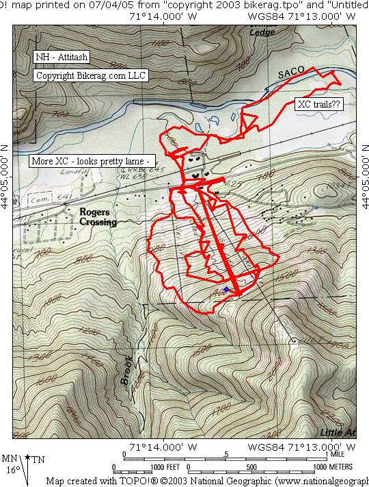
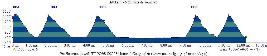
Directions - From 93 take 112 (Kankamancus highway) East to Bear Notch Road, take left and follow all the way to end (watch out for roadies going 40+ mph). Take right on 302 in bartlett center. Travel 2.44 miles Mountain is on right. Description - All in all a great lift accessed DH area. The trails here were much more sick than I expected. Not too much for beginner or even intermediate riders unless you like to walk. There are about 6 or 7 different lines down the mountain, 850 vertical and about .6 miles to 1 mile in length.. Most of the runs were about the same difficulty level - solid expert, plus some Stunts, drops and lines that were well above.. You will find crazy chutes, bunch of drops (many with awkward landings), Awesome rock gardens, couple berms, switchbacks, ramps and log rides.. I must say the built up stuff is pretty lame for a resort as far as construction.. Pallet runged ramps and log rides questionable at best.. But still some great stuff, this place more than others LOOK before you ride.. Just ask Konadelux.. There were just a couple easier trails - A - B - C - Q - T Trails were very well signed but map really sucked (minor detail).. The XC trails across the street seemed pretty lame.. I only poked my big nose in, pulled a Dana Carvey and deemed it not worthy.. XC was flat, some cool singletrack, some buff doubletrack, lots of hoof marks and poo poo everywhere.. Some very scenic sections along the saco river.. Loops - Pre-ride Music: |
Total Miles: |
|
|
Disclaimer: Caution - Use this map at your
own risk. Bikerag.com and affiliates will not accept
responsibility for an personal injury, property damage or trespassing while
using this map. Trail users shall obey all signs, and always obtain
permission from the land owner to use trails for any sporting activity.
Permission to use trails should not be assumed. This map simply
contains topographical information and trails that existed at one time.
Trails shown maybe be missing, not accurate, closed, overgrown etc.... |
To
view larger version of map, right click on map and select View Image. |
| ||||||||||||||||||||||||||||||||||||||||||||||||||||||||||||||||||||||