


|
MA - Tote Road - Whiting Reservoir - Mountain Bike Trail Review with Map and Pictures |
||||||||||||||||||||||||||||||||||||||||||||||||||||||||||||||||||||||||
Directions - 91 north through springfield, exit
17, rte 141 towards easthampton (for 1.2 miles).. Park across the
street and just past Wycoff golf course.. The parking area parallels
rte 141.. Go back across the street and enter the fire road past
the main reservoir gate.. To get to the mount tom trails, bear left
around the res and look for a short piece of singletrack on the left..
If you miss it you will just take countless laps around the res.. |
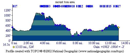
Description - Good steep climb followed by great slickrock sections, some drops, some boney stuff, some nice single track, some rocky fire roads.. Lots of hikers here.. Mountain biking is not allowed on some trails (like m&m we here) so look for no-bikes signs.. Pre-ride Music: Something
by Enya, followed by Guar.. |
Total Miles: 20 |
|
Elevation Profile -
| ||||||||||||||||||||||||||||||||||||||||||||||||||||||||||||||||||||


