Rating Explanation (0-5) Category:
 |
Overall Rating |
 |
| Adventure |
Climbing |
Free-ride |
Fun |
Fear |
Trail
Enhancements |
Scenery |
Technicalities |
| .2 |
.3 |
0 |
1 |
0 |
.25 |
2 |
.75 |
1.8 |
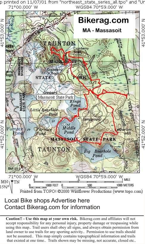
| Directions - Rte 495 south, take exit 5, right
at exit, follow signs for Massasoit state park. Description - Putting
a positive spin on things, this place is a beginners paradise.. Buffed
double track through pine forests with the occasional root garden or small
hill.. There were a couple of small bridges to that were pretty sleazy
too.. I did find one extra curricular stone wall wheelie drop to keep
my heavy glazed eyelids from shutting.. Also a there was a fun roller
rock called pudding rock.. Yup one rock in the whole place..
This place is just like the trail of tears (hold the tears and the hills)..
Oh lots of sand here too, so bring the 3.0 tires - and yes, I know..
Locals tell me there may be a jump somewhere, I couldn't find it.. |
| Pre-ride Music: Slowride, take it easy
- Foghat - thanks KA |
| Total Miles: I would guess 10 or so.. |
| Elevation Change Feet - (40 feet, and that
includes putting the bike back up on the xterra roof) Possible the flattest
ride ever, were we transported to Florida or what??- Elevation
Profile (imagine straight line) |
| Nearest ice cream and coffee: Head back
towards 495, but go to rotary instead of the onramp.. You will find a dunkin donuts and friendlys for ice cream.. Or continue straight for a
couple major intersections and look for the cow colored ice cream shack
where young babes make you thick frappes. |
|
|


