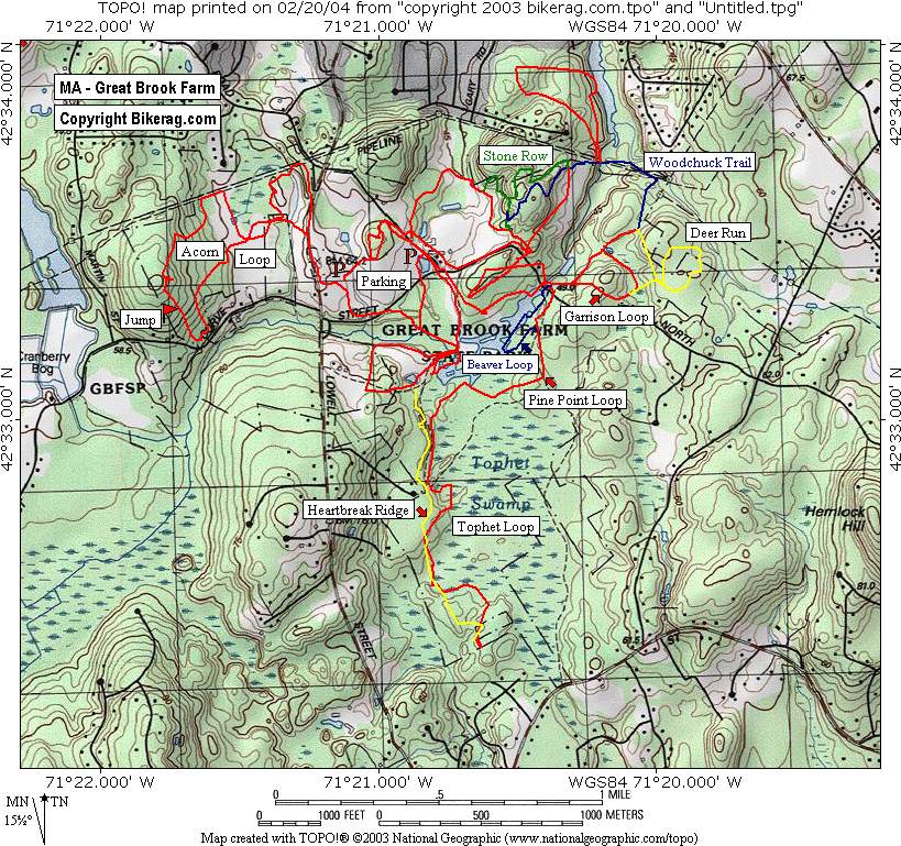
Directions -
From Rt. 128: Take exit
31B. Follow Route 225 West for 8 miles to the Carlisle center rotary, then
turn right on Lowell St. (following the sign to Chelmsford.) Fern's Market
is on the corner. The Park entrance is 2 miles ahead on the right. The Park
Office (984 Lowell St) is just beyond the entrance also on the right. Make
right hand turn onto North Road. Parking area is 1/2 mile down on left.
From the West (Route 2): Follow
to Rt. 495 North. Use directions below.
From the North: Take 495 South
to Exit 34. Follow Route 110 West for .6 miles to Chelmsford Center,
continue through light onto Route 4 South for 1 mile, then take right fork
onto Concord Road towards Carlisle. The Park office is 2 miles ahead on the
left. The Park is just beyond the office , go left on North Rd, parking lot
is 1/2 mile down on the left.
From the South: Take Rt. 495
North to exit 32 (Westford & To Route 225). At the bottom of the ramp go
right. At the lights go straight through. At the T intersection go left
(onto Rt. 225). Follow Rt. 225 till you reach the center of Carlisle (small
rotary with monument in the middle). Go 3/4 of the way around the the rotary
onto Lowell Street towards Chelmsford. The Entrance to the park is two miles
down the road on the right. The Park Office (984 Lowell St) is just beyond
the entrance also on the right.Description - A
decent mix of trails at great brook farm. Nothing crazy technical
here, what you will find is a mix of buff singletrack at the fields edge,
some mildly rocky singletrack in the woods & some fire roads. Bonus
after ride is the ice cream shop couple hundred feet from the parking area.
Some good animal watching as you eat too, saw a goat walk a skinny.
Overall a decent Beginner / Intermediate spot to ride.
Note: There is a fee to park here.
Best trails - Stoner row, indian hill, ummm beaver loop, Keyes Loop
and Fern. (more investigation required) |
| Disclaimer: Caution - Use this map at your
own risk. Bikerag.com and affiliates will not accept
responsibility for an personal injury, property damage or trespassing while
using this map. Trail users shall obey all signs, and always obtain
permission from the land owner to use trails for any sporting activity.
Permission to use trails should not be assumed. This map simply
contains topographical information and trails that existed at one time.
Trails shown maybe be missing, not accurate, closed, overgrown etc.... |