|
|
|
|
| Topo
Map of Area Best Map - DieselBikes.com |
Map Legend | Bikerag Pics |


|
|
|
|
| Topo
Map of Area Best Map - DieselBikes.com |
Map Legend | Bikerag Pics |
|
MA - Lynn Woods - Mountain Bike Trail Review with Map and Pictures |
||||||||||||||||||||||||||||||||||||||||||||||||||||||||||||||||||||||||||
 |
||||||||||||||||||||||||||||||||||||||||||||||||||||||||||||||||||||||||||
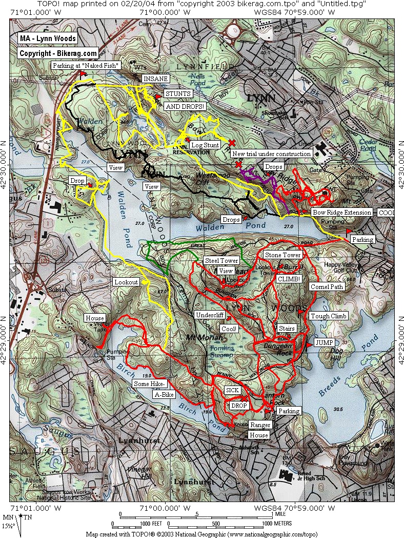
Directions - Get on I-95 North. Take exit 44B for Lynn, Rt 129 East. This will dump you on a rotary, just continue to follow the signs for
Rt 129 east. After you go about two more miles, a small road will go off to your right, which will be marked with a sign
for the Larry Gannon Municipal Golf Course. Follow this road for about 200 yards until it dead ends into a parking lot
with a baseball field on the side. This is the entrance to Lynn Woods. About 200 feet off the end of the parking lot will be
the tail end of Walden Pond. To the left is the bulk of the reservation, including Dungeon Rock. To the right is the technical
terrain that makes Lynn Woods awesome. |
Description - This is the coolest place I have ridden in a long time. Best rock riding in new England I would assume. So many slickrock play areas, little stunts, big stunts - homade ramps - flattened logs. A little bit of everything. A few challenging uphill rock gardens, some great washed out loose downhill's. Cool scenery too if you like that sort of thing. What's it lacking? Maybe some vertical, a seesaw and naked sunbathing babes on all the rocks.. Check it out NOW! Cant believe I waited so long - thanks to Brian for the tour and Fred for urging me to check it out.. Pre-ride Music: Rusted
Root - When I Woke |
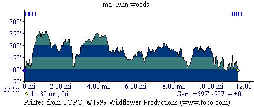
Total Miles: 30?? |
Elevation Change Feet -
597 ft - Profile - Most of
the elevation changes when your rear wheel is off the ground or when the
seat is pressed against your chest! |
|
|
Disclaimer: Caution - Use this map at your own risk. Bikerag.com and affiliates will not accept responsibility for an personal injury, property damage or trespassing while using this map. Trail users shall obey all signs, and always obtain permission from the land owner to use trails for any sporting activity. Permission to use trails should not be assumed. This map simply contains topographical information and trails that existed at one time. Trails shown maybe be missing, not accurate, closed, overgrown etc.... To
view larger version of map, right click on map and select View Image. |
| |||||||||||||||||||||||||||||||||||||||||||||||||||||||||||||||||||


