


|
MA - West Springfield - Bear Hole Excursion - Mountain Bike Trail Review with Map and Pictures |
|||||||||||||||||||||||||||||||||||||||||||||||||||||||||||||||||||||||||
Directions - I heard the parking situation and
trails may have changed, youll have to explore on your own until I get back
there..
|
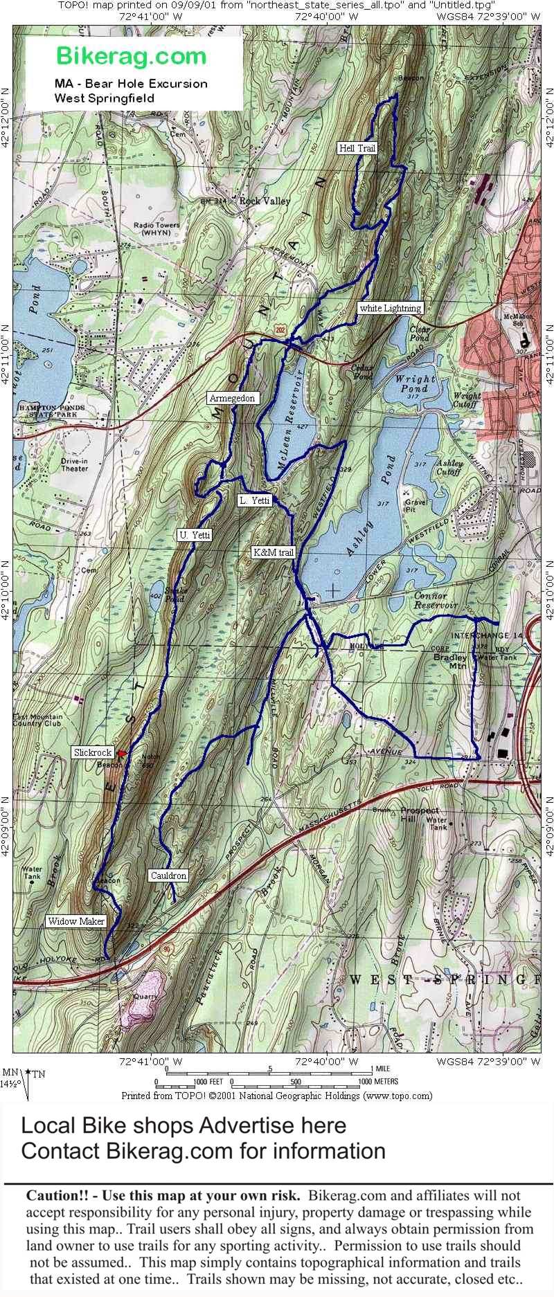
Updated Directions from forum guest - Thanks: There has been new construction near the water tower. I would suggest parking on 202 at the first entrance to the reservoir. There is an exit off 91 or you can take the Holyoke mall (ingleside mall) exit. If you take the mall exit going north, you would take a left off the exit, go up two lights and take a right, go a 1/2 mile up the street past a school and take a left at the next light, the res entrance is right there on the left. You can ride past the reservoirs to get to the trails or cross 202 and do the north side above Holyoke Community College. If you just want to ride the ridge, the trail head is just as 202 crests and begins to head down into Westfield. Follow the white or double white trail markers. If you like to freeride and xc, there is about a 4 - 5' drop at the souhtern end of the ridge between the comcast tower and the old fire tower. Description - Riding in this area definitely proves to be an adventure. A really nice 11 mile loop can be had, on clearly marked trails. The riding starts out on fire roads, but turns into really nice rock single track, with spectacular ridge views, some technicalities but none too extreme. Very similar to Penwood state forest - but completely different. Loops - Follow the double track, over RR tracks, to reservoir, left on reservoir road, left on double track, to K&M trail, to Yetti trail, take right on blue trail up to ridge - hike a bike - ridge trail down hill, right on fire road QUICK left on Armageddon, cross 202 to white lightning, left at tee to fire road, straight across to hell trail back to fire road take right which brings you back to 202, then take the reservoir trails/ roads back to the car. Pre-ride Music: Anything
by Courtney Love |
Total Miles: 25 ish?? |
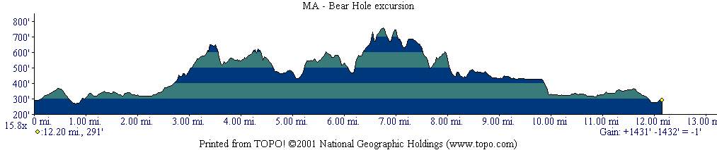
Elevation Gain - 1431 Feet - Elevation
Profile |
|
|
| |||||||||||||||||||||||||||||||||||||||||||||||||||||||||||||||||||


