|
|
|
|
| Trail map | Map Legend |


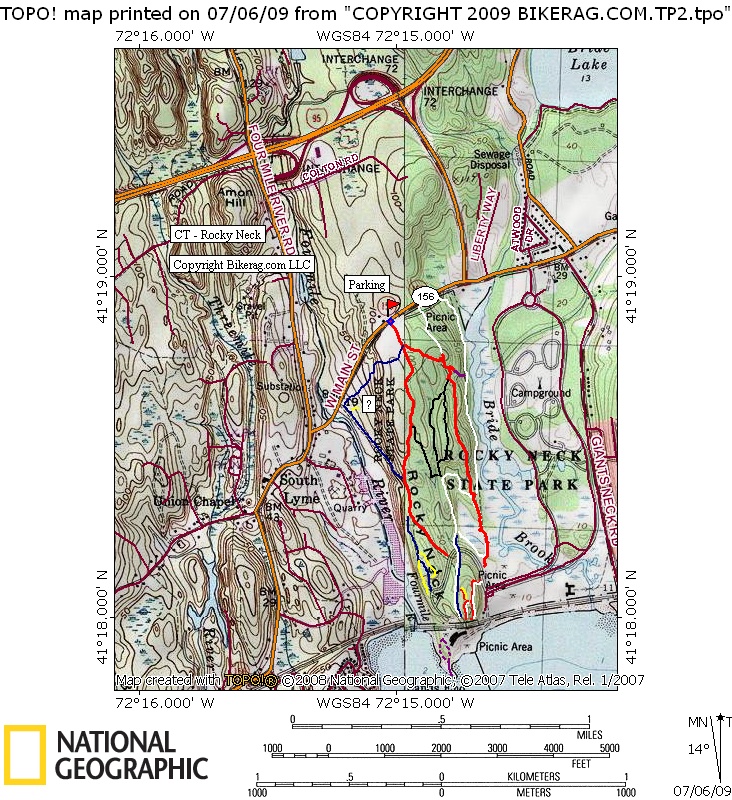
| Rocky Neck state park - Mountain Bike Trail Review with Map and Pictures | ||||||||||||||||||||||||||||||||||||||||||||||||||||
|
||||||||||||||||||||||||||||||||||||||||||||||||||||
| Update: Went back for a quick ride,
ended up being 7 miles of fun.. A few small natural rock jumps, some
tough ups, few rock gardens, few 2 footers and even a 3 footer. Some
fun rock near the water too, but I wouldn't go there if its busy. Directions - From I-95 take exit 72, right at exit, up hill look for parking lot on left. Its that easy. Description - Pretty nice mix of trails at rocky neck, I was pleasantly surprised. Some standard park wide doubletrack, some nice rocky singletrack, and a few really nice slab rock sections with a few things to play on here and there. Nice views of the water, cool wildlife viewing in the marsh area. Not a bad ride if your in the area - little light on mileage, Loops - Ride everything |
||||||||||||||||||||||||||||||||||||||||||||||||||||
| Pre-ride Music: | ||||||||||||||||||||||||||||||||||||||||||||||||||||
| Total Miles: 7 ish? | ||||||||||||||||||||||||||||||||||||||||||||||||||||
| Elevation Change Feet - Pretty flat | ||||||||||||||||||||||||||||||||||||||||||||||||||||
|
||||||||||||||||||||||||||||||||||||||||||||||||||||
| Disclaimer: Caution - Use this map at your own risk. Bikerag.com and affiliates will not accept responsibility for an personal injury, property damage or trespassing while using this map. Trail users shall obey all signs, and always obtain permission from the land owner to use trails for any sporting activity. Permission to use trails should not be assumed. This map simply contains topographical information and trails that existed at one time. Trails shown maybe be missing, not accurate, closed, overgrown etc.... | ||||||||||||||||||||||||||||||||||||||||||||||||||||
| To
view larger version of map, right click on map and select View Image.
|
||||||||||||||||||||||||||||||||||||||||||||||||||||