|
|
|
|
| Bikerag Topo Trail Map - Best map --Official Map Link |
Map Legend | Bikerag Pictures |


|
|
|
|
| Bikerag Topo Trail Map - Best map --Official Map Link |
Map Legend | Bikerag Pictures |
|
Rockland Preserve in Madison Mountain Bike Trail Review with Map and Pictures |
|||||||||||||||||||||||||||||||||||||||||||||||||||||||||||||||||||||||||||||
Update 2017.
|
Singletracks of Rockland Needs your help! Skills area and Pump Track coming soon :)
Donations toward RBP are tax deductible
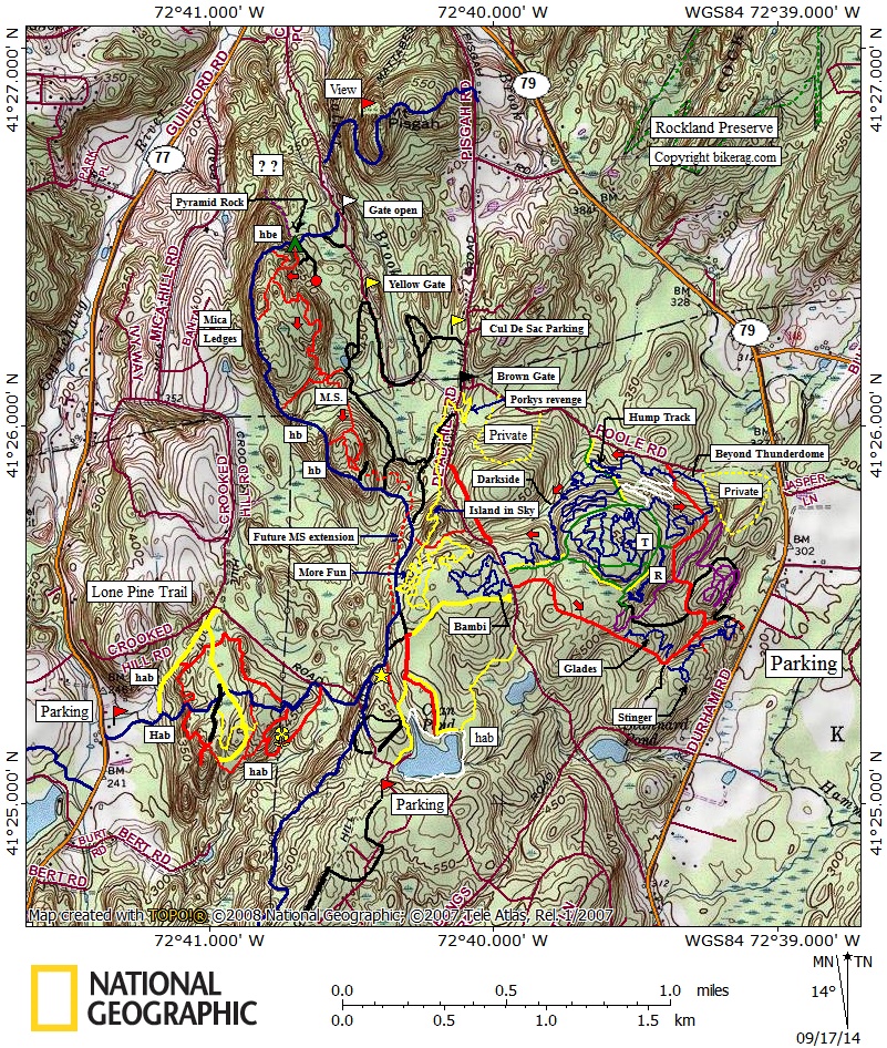
There is no night riding at Rockland. Previous incidents have led to discussions of trail closure. Cars parked in the lot AND any riders will be ticketed after sunset. Seriously, lights on your bike means lights out for these trails. Update 2016 June - Holy Jesus we added new trails. Dirt church - northern exposure - Bee line - Erratica - and intestine. Building is now complete at rockland, we ran out of land essentially. Just maintaining this place is a full time job though. Tables have been freshened up on thunderdome and beyond. Update 2014 Sept 17th - Bambi and Mag-5 trail now complete. Bambi is beginner, Mag-5 is expert and technical. Amazing how this network has developed in 2 years. Huge thanks to Jason for creating this great riding area. Update 2013 October 2nd - Darkside trail is complete and ready to ride. Map has been updated. Update 2013 - April 2nd - We had a rough winter for trail building but things are now in full swing. The thunderdome trail is rough cleared and rideable. Beyond thunderdome should be rideable top to bottom in a few weeks. Then the fun part begins, nip tucking the trail and shaping some dirt. This is a work in progress, but promises to be a great riding area some day! Jason (Mr Rogue Hoe) is busy with setting up a Nemba trail school day, working on trails, signage, trail days, you name it. Update 2012 part II - More new trails going in at rockland if you haven't already heard. Next batch of trails will be more technical in nature due to the natural landscape. Signup on singletracks of rockland facebook page if you wish to help out on trail days. Huge thanks to Jason & the town for letting me "put my stamp" on the ever progressing trail system of Rockland preserve! Its gonna be Good!
Update 2012: Great news! There are new Trails going in @ Rockland thanks to the efforts of Jason Engelhardt a local school teacher. Jason has gone thru the proper channels and has official approval to build several miles of trails. So far the new singletrack only totals about 2 miles, but it is very well built flowy singletrack. Check for trail days via nemba and rides online via singletracks of rockland on facebook. New trails are shown in purple on map but not blazed yet. You can easily get in a nice 7 mile ride by including the new trail up and down + some surrounding doubletrack & singletrack trails..
Directions - From Durham center take 79 south for about 3ish miles.. Look for parking on right, see map in picture post. Description - This is a small trail network near the mattabasset trail. Most trails are wide roads, non-technical. Few bits of singletrack, rockland trail had some nice sections.. Rockland loop was abandoned singletrack.. All in all might be a good area for beginers, or if you just need to use the trails to connect bigger loops but dont drive too far to ride here.. Summit loop was as anti climatic as blue iris on the sybian (OLD WIDE fire road) Loops - Pre-ride Music: |
Total Miles: 7-10.... 8 miles of
singletrack now! |
Elevation Change Feet - 321 |
|
Disclaimer: Caution - Use this map at your
own risk. Bikerag.com and affiliates will not accept
responsibility for an personal injury, property damage or trespassing while
using this map. Trail users shall obey all signs, and always obtain
permission from the land owner to use trails for any sporting activity.
Permission to use trails should not be assumed. This map simply
contains topographical information and trails that existed at one time.
Trails shown maybe be missing, not accurate, closed, overgrown etc.... |
To
view larger version of map, right click on map and select View Image. |
| ||||||||||||||||||||||||||||||||||||||||||||||||||||||||||||||||||||||


