|
|
|
|
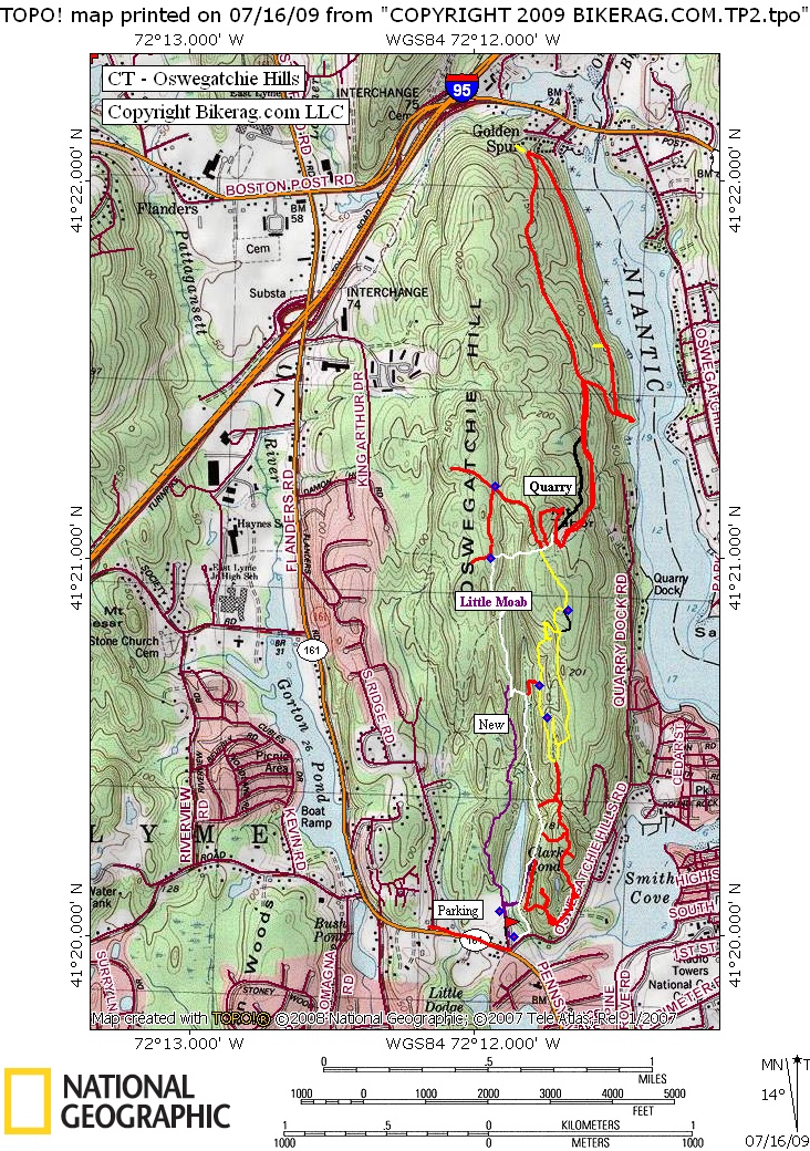
| Topo Trail Map | Map Legend | Bikerag Pictures |
|
CT - Oswegatchie Hills - Dunkin Donuts Trail - Jackass Trail - Mountain Bike Trail Review with Map and Pictures |
||||||||||||||||||||||||||||||||||||||||||||||||||||||||||||||||||||||||||||||
Update 2009 - Great stuff at OZ.. Might
be a few new trails since last time, great rock features, few drops, ups,
and really nice old school technical singletrack with very few trail
braids!..
|
Directions - To Niantic take I-95 (N or S) Exit 74 - Flanders Rd. Rte. 161, take right heading East on Flanders Rd. Roughly 2 miles look for Sunoco station on right. Across the street from station take a left onto Memorial Park Dr. and park in dirt lot at the beginning of the road. Description - Oswegatchie Hill (spelled correctly) formerly known as Dunkin Donuts trail on mtbr or Jackass to locals is a really cool small riding area in Niantic.. The ride consists of a variety of terrain ranging from double track to sweet rocky single track and a good amount of slick rock.. The rocky stuff isn’t super technical with the exception of the Rabbit hole.. Many have “stuck it” in the bunny hole.. The good single track is moderately technical, a tad bushwacky (to change soon I bet), and super fun with nice patches of rock and fun lines.. You don’t have to look off the trail far to see lines lurking in the bushes.. There are 2 really cool quarry areas that are SUPER small and SUPER dope. Youll wonder am I in CT or Utah?? Some nice lines with mulitple small drops and rollers, short lived but sweet, good play area, you know for the kids… Some nice views of the Niantic river mid–ride, you’ll smell the aroma of the sea and 2.5 lb lobsters ready to be boiled and cracked with a hammer.. Some Fire road and double track separates the good stuff but it wasn’t bad at all.. One section they call mini Moab had lots of super flowy rock with some small moves, one nice 3.3 footer.. Would I go back? Hell yes, best new trail I have found in a while.. Pre-ride Music: |
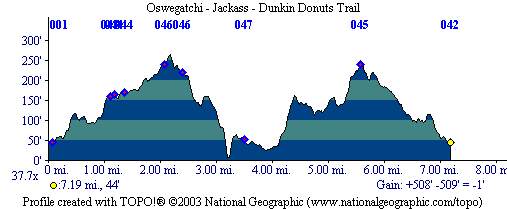
Total Miles: 7-10 |
Elevation Change Feet - Elevation
Profile:
|
 |
Nearest Coffee, Sushi or other food: Dunkin Donuts, Rte. 161 - Flanders Rd, on left heading to ride parking. Illiano's Grill - great pizza and dinners, 228 Flanders Rd. Rte. 161, on right heading to ride parking.
|
Disclaimer: Caution - Use this map at your
own risk. Bikerag.com and affiliates will not accept
responsibility for an personal injury, property damage or trespassing while
using this map. Trail users shall obey all signs, and always obtain
permission from the land owner to use trails for any sporting activity.
Permission to use trails should not be assumed. This map simply
contains topographical information and trails that existed at one time.
Trails shown maybe be missing, not accurate, closed, overgrown etc.... |
To
view larger version of map, right click on map and select View Image. |
| ||||||||||||||||||||||||||||||||||||||||||||||||||||||||||||||||||||||