|
|
|
|
| Topo Trail Map | Map Legend | Bikerag Pictures |
|
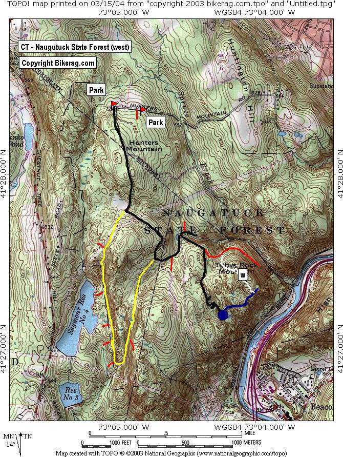
Naugatuck state forest - West Side - Toby's rock mountain - Mountain Bike Trail Review with Map and Pictures |
||||||||||||||||||||||||||||||||||||||||||||||||||||||||||||||||||||||||||||||
Directions - 2 parking areas in
completely separate areas.. The area that I parked at requires quite a
bit of fire roading but here goes.. Take route 8 to 63 north - 2nd
left on scott street and first left on Lewis wich turns into Hunters
Mountain Road.. From scott you travel about 2 miles and park at end
near green gate |
Check out NEMTB.com for alternate parking and an incomplete trail map & pics.. Description - Some cool trails but they are hard to find.. Some nice rocky technical trail (blue), really nice slickrock (short but sweet) and some technical super boney double track, bowling ball style, and a bonus stream trail.. Many more trails to map.. Loops - From bikerag map - to get to the goods you basically start on the gravel road and follow it to the end.. At one point though you will hit a Y intersection, there will be a dirt mound jump at the crotch of the Y and a psuedo bench nearby.. TAKE A RIGHT at the major Y.. There is a less major Y after that that is more of a trail left, double track... Anyway - follow to end, cul de sac take left on blue, look for white after that, I didnt follow the blue to the end quite yet.. The rocky boney trail described is accessed by climbing power lines and bearing left from the top. As you can see on the map there were many unexplored trails from here.. Pre-ride Music: Prodigy
- FIre starter |
Total Miles: 10ish |
Elevation Change Feet - Our 8 mile exploration
was 1000 vertical |
|
|
Disclaimer: Caution - Use this map at your
own risk. Bikerag.com and affiliates will not accept
responsibility for an personal injury, property damage or trespassing while
using this map. Trail users shall obey all signs, and always obtain
permission from the land owner to use trails for any sporting activity.
Permission to use trails should not be assumed. This map simply
contains topographical information and trails that existed at one time.
Trails shown maybe be missing, not accurate, closed, overgrown etc.... |
|
 | ||||||||||||||||||||||||||||||||||||||||||||||||||||||||||||||||||||||


