|
|
|
|
|
Merli Sarnoski Trail
Map Fell Mountain trail Map Link to another map (doesn not show logging) |
Map Legend | Bikerag Pics |


|
|
|
|
|
Merli Sarnoski Trail
Map Fell Mountain trail Map Link to another map (doesn not show logging) |
Map Legend | Bikerag Pics |
|
PA - Fell Mountain - Merli Sarnoski Park -
Mountain Bike Trail Review with Map and Pictures |
||||||||||||||||||||||||||||||||||||||||||||||||||||||||||||||||||||||||
Directions - Take 84 west, exit for 247 (old
exit #4?), to rte 6 east to carbondale.. LEft at exit, right at light.
Follow signs for business rte 6 into town, left at light, pass dunkin donuts
on left take a left at the second traffic light after dunkin donuts, down
hill take a right at the stop sign that says (stop, unless your going right
- too funny), anyway, follow rte 106 for 3.44 miles and take a left on sandy
bank road, drive .33 miles and look for main entrance to Merli Sarnoski park
on left, drive up steeeep hill, parking lot at the top.. |
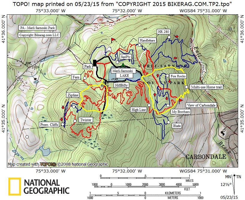
UPDATE 2006:!! A portion of merli has been LOGGED section of red trail and branch trails are abandoned.. As of October 2006, there are still a good amount of rideable trails (9 miles or so), but im not sure if there are more areas to be logged.. There are several discussions on mtbr Forums on the issue. Sounds like before new trails go back in quite a bit of planning (IE bureaucracy) needs to take place to satisfy all users and the park manager.. Some of the new trails I checked out this year (new to me that is) were great!! Handlebars, HR 280 & blade, all awesome.. HR 280 had some sweet slick rock sections! Description - This park has some great singletrack, technical rocky riding.. There are small to medium sized ledges everywhere.. The trails usually run below, on top, or in-between them.. The main Loop is marked with a peach diamond and a blue dot.. There are side trails everywhere, some are short some are fairly long, most proved to be great technical trails.. Although the map is not complete it should help more than the posted park map in the office which you cant take with you.. See pics for that one.. This is a solid intermediate ride, nothing too gonzo, but great constant fun rocks to ride.. Lots of slickrock sections, a few small drops.. Mountain bikers maintain and build these trails and do a superb job!! With a little work this area would be comparable to trumbull CT for ledge drops.. There are cliffs EVERYWHERE, all shapes and sizes.. This was our first ride on an east coast MTB trip and well worth the stop.. Pre-ride Music: Fat
Boy Slim - Santa Cruz (better living through chemistry CD) |
Total Miles: 15 or so |
Elevation Change Feet: 10 mile loop was
1200 vertical |
| ||||||||||||||||||||||||||||||||||||||||||||||||||||||||||||||||||||


