|
NC - Laurel Mountain - Pilot Rock - Mountain Bike Trail Review with Map and Pictures |
||||||||||||||||||||||||||||||||||||||||||||||||||||||||||||||||||||||||
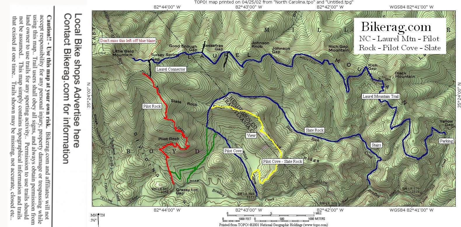
Directions - Take 280 to North mills river
road, will eventually turn to dirt FR1206 or yellow gap road, look for
laurel mtn trailhead on right, park there or anywhere past that so
you can get rid of more vert. from the start. |
Description - Category - Intermediate plus, Expert, Expert Plus - Rock gardens, rocky switchbacks, Views and Vert. This is possible the best ride I have ever done! Starts out with a 7 mile climb up 2000 feet or so. Personally I felt like I was riding downhill half the time, but maybe im just numb.. In any case its a very gradual climb up till the last 1/2 mile with has some hike a bike (200 feet or so if your good - reallll good).. The trail up is not boring!! Its pretty nice rocky singletrack that has some fun downhill sections to keep you going.. Every ridge you ride around has laurel caves on one side and tall trees on the other. Lots of Dejavou (or for you it may be Dejapuke!.. Took us an hour to reach the top. Laurel connector is a short uphill trail (left fork - unmarked) that will bring you to Pilot Rock trail. Left on Pilot rock the fun continues (10 fold), straight down the ridge line, couple logs to hop, then look to your left for view of slate rock where you can ride when you get to the bottom if you have lots of steam left! Pilot rock trail turns rocky, some slickrock, some chickenheads and medium sized rocks are scattered through an intensely cool double behind the seat switchback through solid rock channel.. We cleaned it. Onward to several more awesome rocky switchbacks, littered with water bars and rock drops, ridden bus driver style, behind the seat. After the switchbacks a GONZO rock garden appears - all ride-able, great stuff.. Your hands are probably tired now as you hit the last section of dirt water bar mounds.. At the bottom take a left on the dirt road and ride back to the car. OR!! - If you still feel fresh - Take a left before you hit the dirt road onto basically a grassy fire road with single track in the middle of it.. Its a little bushwacky, but trust me it will get you somewhere. Keep following it straight even if the single track disappears from time to time.. Take a left at the first T in the trail and stay right at the next fork. This trail has nice log obstacles and takes your to pilot cove loop! When you hit the pilot cove loop you will see a well worn in trail and a pile of rocks with dog poop on it (yes im sure the dog poop will be there forever!).. Anyway take a right and enjoy the ride down, left on pilot cove slate rock, intense climb up 1000 feet, then back down pilot cove (yes again), to fire road, then left back to car.. OR !! On your way back from pilot cove, feel free and take a left on slate rock trail, Just go as far as you want, the ride back will be all downhill.. See Pilot cove slate rock review for more details We did the above description all in one day 5 hours total, 3 1/2 hours of actual moving (lots of oooo ahhhh pics as you will see). Total trip was 21 miles and 5,560 feet of vertical.. No joke.. What an epic adventure - DON'T MISS THIS ONE!!! Pre-ride Music: Pink
Floyd - Comfortably Numb |
Total Miles: 14 (with no wrong turns) - Laurel mountain loop ONLY!!! |
Elevation Change Feet - 3000 feet |
|
| |||||||||||||||||||||||||||||||||||||||||||||||||||||||||||||||||||


