|
NC - Daniel Ridge Loop & Caney Bottom (out and back) - Mountain Bike Trail Review with Map and Pictures |
||||||||||||||||||||||||||||||||||||||||||||||||||||||||||||||||||||||||
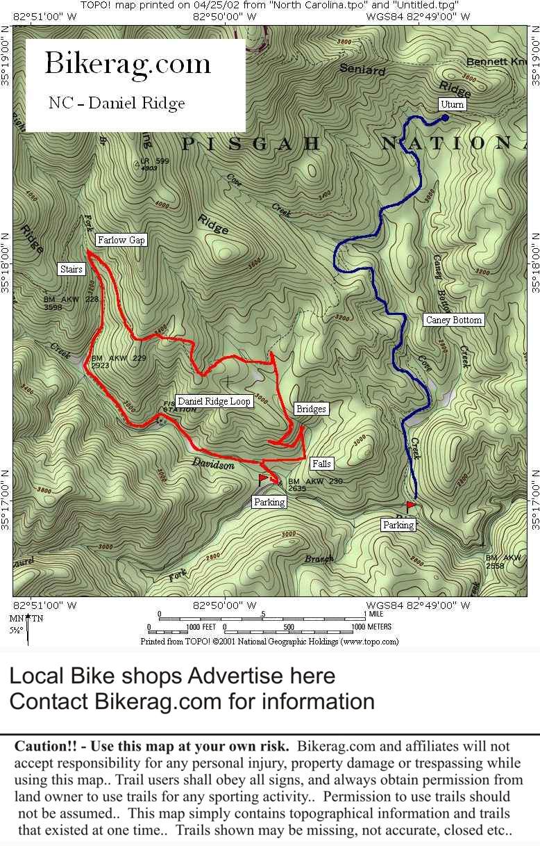
Directions - From Junction of 276 and 280,
take 276 north for around 4 miles and take a left onto FR 475, past fish
hatchery, turns to dirt, follow and look for second gate on right (first
gate is Caney bottom trailhead. |
Description - Category - Intermediate, expert, Switchbacks, log bridges, singletrack, technical rocks, waterfalls, jumps, burms, R. Tunnels First of all since Daniel ridge was short ride I suggest combing it with Caney Bottom like we did.. Daniel ridge was just plain awesome. Ride the trail counter clockwise unless you want a very technical rocky climb and smooth descent. The start of the ride begins at the coolest waterfall I have seen, trail begins up a short set of ride-able steps, then rocky, rooty single track with a pretty hard switchback.. Easy climb so far, then trail crosses many streams with tons of cool bridges (some logs, some planks etc..). Onward to buff single track next to field then pretty steep double track red dirt climb up to the top (cleanable). Now its all downhill for a while!! Great single track rocky downhill, cool rollercoaster DIP.. Stream crossing, then left on farlow gap stairs (pretty tough). The trail now follows the stream below.. Couple of great rocky technical sections, one section of trail is on the edge of an 80 degree slope (more exposure than Moab! - if that turns you on).. Downhill back to the car.. Stop at car and reload if you need to. Left on road .6 miles left at gate, follow fire road and look for left on blue blazed Caney bottom uphill.. Goes up for like 2.8 miles, but pretty easy. Trail is rooty, with several AWESOME stream crossings - all different.. There are log rides, steps, jumps, banked turns, and errosion gullies on this trail.. Get to the end, U-turn, back down to the bottom - best out and back I have done.. Lots of fun, lots of air with technical stream crossings in between.. My only complaint is that its not longer, but combined with Daniel ridge, I was beat. Back to the bottom, right on road easy ride back to car.. Pre-ride Music: Anything
from Fockers Frida On Acid 3 |
Total Miles: 12 miles for BOTH rides |
Elevation Change Feet - 2000 feet (both rides) |
|
| |||||||||||||||||||||||||||||||||||||||||||||||||||||||||||||||||||


