|
|
|
|
| Topo Trail Map | Map Legend | Pictures |


|
Tuscany - Mountain Bike Trail Review with Map and Pictures |
|||||||||||||||
| Review By Cliff Krolick and Katy Robinson Back Country Excursions - Thanks!! | |||||||||||||||
|
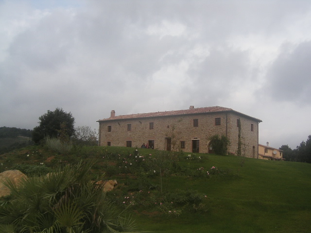
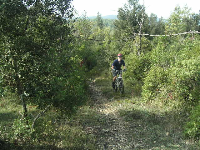
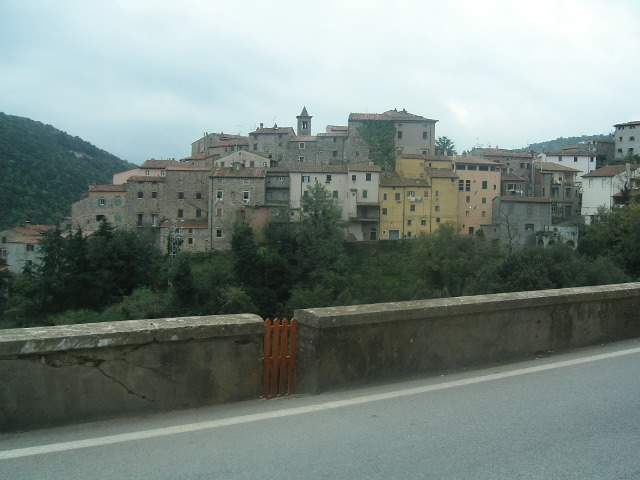
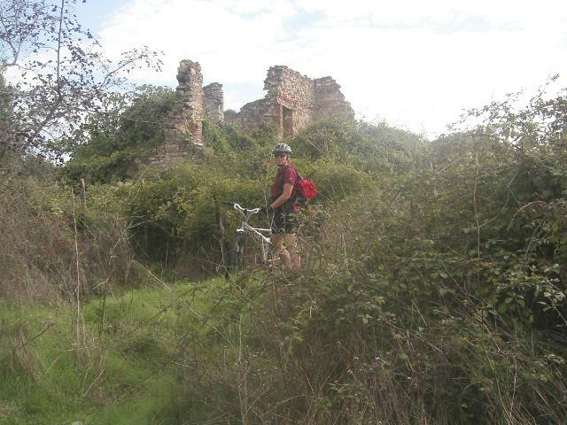
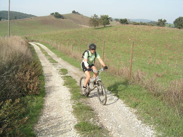
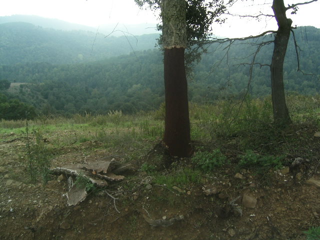
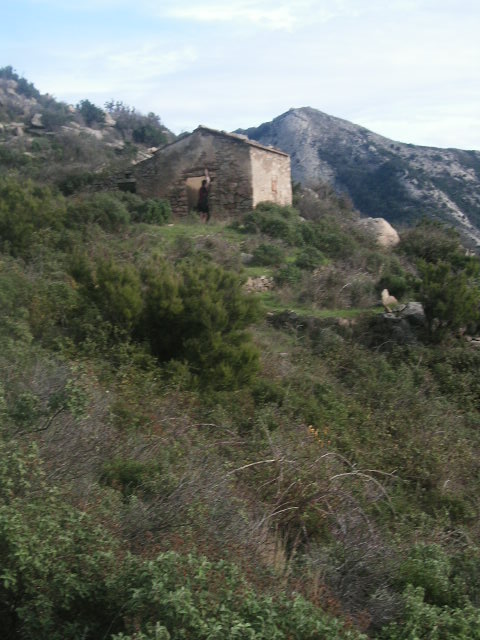
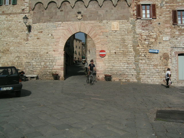
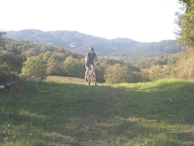
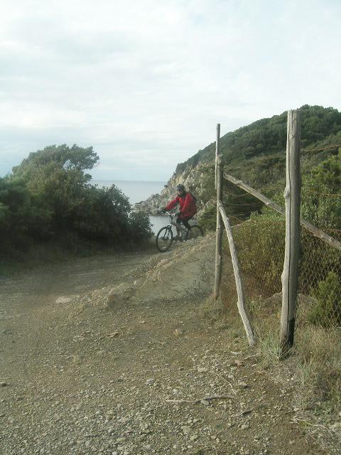
ROCKIN’ IN TUSCANY What are the chances of having a stranger in Tuscany email you and invite you to come and stay at their villa and ride their trails? And what are the chances that you would believe that this was a real invitation and not spam? Luckily for us, just this once we opened the email rather than delete it, and found that it was the real deal! Massimo and Gin, innkeepers of Tenuta di Seripa - a classic guest villa in Tuscany, invited us to be their guests with the intent of organizing a mountain biking tour for our clients. Photo 1 Yes, an opportunity that we could not pass up. Naturally, we packed our bags and bikes and headed to the hill country of Tuscany for two weeks of exploration and adventure in early November. Riding a mountain bike in Tuscany is the stuff of magic. Biking slows down the pace of explorations, giving you the opportunity to experience the cultural, historical, and gastronomic adventure that is Italy on an intimate level. Narrow lanes, abandoned villas and centuries-old church ruins overgrown with grapevines beckon you with easy access; not afforded by motor transport, these medieval walled cities are just one of the many unforgettable experiences to come. You may come upon pastoral vistas and ancient terraced landscapes reminiscent of another time and place. You can smell and savor the fragrance of wild herbs as you brush past them in the Mediterranean scrub. Picture 2 - Picture 2A And after a day of riding, nothing tastes better than a simple meal of fresh bread soaked with olive oil, local meats and cheeses, and a good bottle of village wine. Our hosts, Massimo and Jin, have recently finished renovations on a magnificent farmhouse-turned-villa deep in the Tuscan hills. The property, once an active farm, is comprised of over a 100 hectares, located in the center of Poggio Neri Forest park. The closest town is the sleepy hill village of Sassetta with only 600 inhabitants, and life here is slow and peaceful. Picture 3 After a wonderful welcoming lunch of Tuscan bread soaked in home-grown olive oil, homemade ravioli with a filled with greens harvested from the fields and chestnuts harvested from the woods, accompanied by Massimo’s family’s wine, and ending with gelato and another villa specialty - homemade lemon liqueur, we settled into the comfortable living room at the villa to plan our week of biking. Massimo pulled out a trekking map of the area, with many hiking and biking trails already marked for us. The hills are riddled with old farm roads, woodcutters’ paths and animal trails frequented by roebuck, fallow deer and wild boar! The sun was setting before we finished settling in, so riding would wait until the next morning. We decided to start our riding in the woods, exploring the miles of trails laid out for us by Massimo. Fueled with more homemade goodies from the villa’s kitchen and some powerful Italian espresso, packing a simple lunch of salami, cheese, bread and wine, we took off! Trekking is a big business in this part of Tuscany and the trails were well-marked…at least the trails that were recommended to us. It did not take us long to start exploring some of the unmarked animal trails and woodsman’s paths “off the gird”. Single track was everywhere, constantly intersecting and crossing the main trekking paths. Deciding which trail to follow was the hardest part of the adventure. The hills were full of surprises. We stumbled upon numerous abandoned villas, Picture 4 each one tempting us it’s rescue from the overgrown grapevines and bird nests; stunning vistas of picture perfect vineyards and olive groves; and once a meadow filled with hundreds of curious sheep guarded by a Sardinian sheep dog who was quite concerned about our bicycles. Picture 5 The woods were filled with fragrant wild herbs, and as we rode along our legs and arms brushed against them. The aroma of rosemary and oregano was incredible. We also came upon many local folks foraging, carrying baskets filled with wild foods such as mushrooms, chestnuts and herbs. The woods of Poggio Neri were regularly harvested for cork, and some of the best single track was actually woodsmans’ paths thru the cork forests. Cork is actually the outer bark and is peeled away about every 9 years without damage to the tree, but it was eerie winding thru a grove of naked trunks. Picture 6Wild boar also liked these more open trails so we occasionally had to divert due to a torn up section where the pigs had been digging for food…luckily wild boar are quite shy so we never had a direct confrontation! At the end of the day, we came upon an abandoned building which turned out to a 12th century church constructed of hand-hewn marble. Outside the church was a mountain spring, used by Christian pilgrims passing thru almost a thousand years ago. It is still used today by the locals to fill their water jugs! Drinking from such as ancient fountain was an amazing experience. Picture 7 There were enough animal paths and hiking trails to fill up a month of riding in the area, but Tuscany is not all about the woods! After three unforgettable days of chasing thru the endless maze of Mediterranean herbs, oak, cork and chestnut forest we headed towards civilization. We were intent on exploring the ancient walled hill towns of Sassetta, Suvereto and Castegneta Carduci. Picture 8 These towns were originally strongholds for protection of the different warring Mideaval “podesta” who ruled them. Historically these heavily fortressed walled cities were the center of economic and cultural life in Tuscany. Maps of the area showed an endless network of ancient roads connecting them with the surrounding farmlands. For protection, the towns were perched on hilltops or hanging onto steep precipices on hillsides. As you may imagine, riding to town involved climbing. Even though the network of old roads actually followed the footpaths of ancient times, straight up and over ridges connecting town to town, naturally these dirt roads were still our chosen route. We readied ourselves for the challenging ascents. Our reward, the views from the tops of the hills, were well worth the effort. Incredible views of the vineyards and olive groves swept all the way out to the Mediterranean sea. Picture 9 - Picture 9A The descents were unbelievable! The gratifying downhill from the hilltop above Sassetta down into Suvereto was a non-stop 10-kilometer run. Tuscany still follows the old daily rhythms. From 12:30-4:30 the town closes and everyone goes home. This timetable required a little advance planning, as we had to find a lunch spot before the 12:30 bells sounded. We discovered wonderful little cafes specializing in dishes made fresh foods in season such as porcini mushrooms, chestnuts, and wild boar, and always accompanied by first-squeeze olive oil for dipping. Other times, if the weather was inviting, we followed the locals into their favorite food shops, procuring a simple feast of fresh mozzarella and unsalted Tuscan bread to accompany the delicious salty Tuscan salamis. If we were lucky, the weekly produce truck would have setup in the central piazza, allowing us to pick out a clump of local grapes to go along with our meal. Surprisingly, picnic spots were easy to find - just find a set of sunny steps out of the breeze and sink back and soak in the warmth of the ancient stones of a church tower or a fortress wall. These walled towns were virtually deserted every afternoon. Biking in the streets and lanes was like riding through a video game. Narrow cobble stone streets, just wide enough for one car, ended in steep stone steps that tested our suspension. Lanes just wide enough for two pedestrians went under low arches that opened up to sunny piazzas, steep alleys stopped at a nun’s cloister or a small cathedral, bridges arched over ancient cart ways and looked out on the valleys below thru narrow openings in the stone and mortar fortress walls. Everywhere there were wonderful ancient doors of all colors and construction, all surrounded by terracotta planters perched on every available surface. Riding in these towns was a fun freeride urban assault! Picture 10 We had had 6 days of intense riding and were totally saturated with the magic of the Tuscan hills. Still, Massimo and Gina suggested that we investigate one more set of trails to make our trip complete in the coastal area around the Bay of Baratti including the ancient city of Puplonia. Centuries before the Romans, this part of Tuscany was inhabited by the Estruscans. They were highly civilized people who based their livelihood on trading and working in the iron found abundantly in the area. Puplonia, originally an Estrucan city famous in the ancient world, was built on the top of a hill surrounded on three sides by the sea to defend against pirate attacks! After the steep climbs of the hill country, the coastal ride was a mellow break for us. We followed sweet single track thru sleepy fishing villages, past secret coves, following a high trail paralleling cliffs overlooking the Mediterranean, across grassy plateaus high above the ocean, riding thru tunnels in the scrub, past families harvesting olives, and onto sandy dunes with majestic towering umbrella pines overhead. Picture 11 Along the way, we took a side trip into an 80 hectare
archeological site where well-preserved ruins of the ancient Estruscans were
visible. The trails in the park took us past a fascinating cave necropolis,
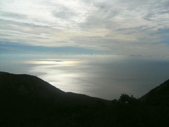
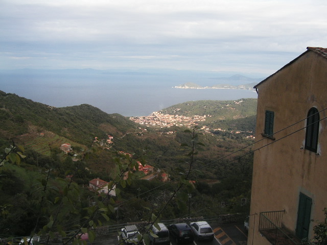
large ancient stone quarries, and an early metal working site. Once again, the climb Puplonia and then the hike up the steep steps of the tower there were worth the effort. A gorgeous panoramic view of the seven islands of the Tuscan archipelago, including the much written about island of Monte Cristo awaited us. Picture 13 Massimo and Gina were right, a tour of Tuscany would not have been complete without experiencing the sea, but one day was not enough. We decided to spend our last few days exploring the largest of the islands we spied in the distance from the fortress tower - the Isle of Elba. The Isle of Elba (Isola d' Elba) is characterized by never ending hills and mountains resulting from its recent volcanic past, breathtakingly ringed with pristine beaches, packed with rugged vegetation. Elba's most famous resident was Napoleon, who spent 9 months in exile (May 1814 - February 1815), after the fall of Paris. Elba is now vacation destination for locals and Europeans alike. Following a week of quiet villages, vineyards and woods, Elba's bustling tourist activity put us in a holiday mood. Pouring over trekking maps of the area, we planned a long ride on a trail in the highest mountain range on Elba. Our route took us from the seaside resort of Chiesse over Mt. Capanne to the hill town of Marciana, the highest village on the island. The ride turned into a hike-a-bike, as the mountains there were much more severe than the mainland. The riding that we did was on slick granite or very narrow goat trails. Even so, the day was incredible. The Chiesse side of the island was very arid and open. Pear cactus were in full bloom. Picture 14 Thevalley was lined with terraces where old grapevines had been replaced by broom and rockrose. Amazingly, the views of the sea and surrounding islands just got better as we went higher. We stopped for lunch at the ruins of a small chapel dating back to the beginnings of Christianity where we explored a deserted stone shelter once used by shepherds. The descent followed a lovely path from the Madonna del Monte shrine, and down steep stones steps into the ancient village of Marciana. Picture 15- picture15A Our return route to Chiessi was a piece of cake. Starting from the Marciana, one of the highest points on the island, we had a sweet, hour-long downhill ride on tarmac. The road was carved into the side of the mountain, with steep rocky slopes on one side, and a sheer drop to the sea on the other and the views of the Tuscan archipelago were spectacular the whole way. It was the perfect end to an incredible trip. Mention the word “Tuscany” and images of castles and villas, peaceful vineyards and silver olive groves, sunlit seas and colorful vistas, delicious foods and perfect wines shared with friendly folk, and a slower pace of life all come to mind. For us, Tuscany was these things and much more. Discovering the hidden charms of this magical land could not have been better for us than touring the back roads and hidden paths on our mountain bikes. We look forward to our next adventure in this gentle, ancient land. About the authors: Cliff Krolick and Katy Robinson run Back Country Excursions, a mountain biking center and lodge in Parsonsfield, Maine. They offer off-road mountain bike vacations, rentals, lessons, and guided riding for all levels. In addition, they lead international trips for bikers to Costa Rica and Tuscany during the off season. For more information, check them out www.bikebackcountry.com. |
|||||||||||||||
|
|||||||||||||||
| Disclaimer: Caution - Use this map at your own risk. Bikerag.com and affiliates will not accept responsibility for an personal injury, property damage or trespassing while using this map. Trail users shall obey all signs, and always obtain permission from the land owner to use trails for any sporting activity. Permission to use trails should not be assumed. This map simply contains topographical information and trails that existed at one time. Trails shown maybe be missing, not accurate, closed, overgrown etc.... | |||||||||||||||
| To view larger version of map, right click on map and select View Image. |


